“O Jeova, namandinangculo sija y chechomo! yan jinasomo mansentadong: Sa y taotao ni y aguaguat ti jatungo:
ni y caduco ti jatutungo este.” Salmo 92:5-6.

Large Medium Original
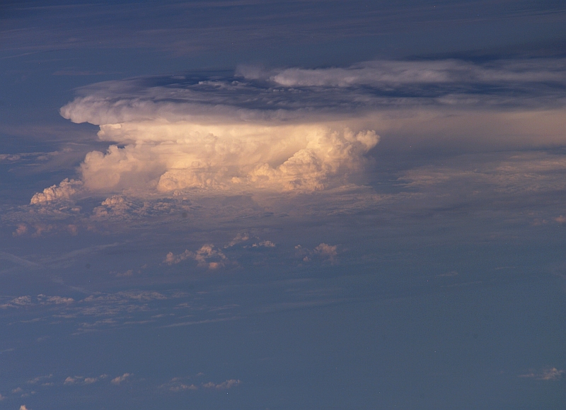
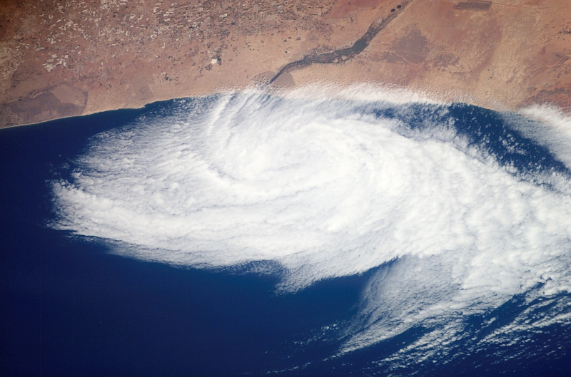
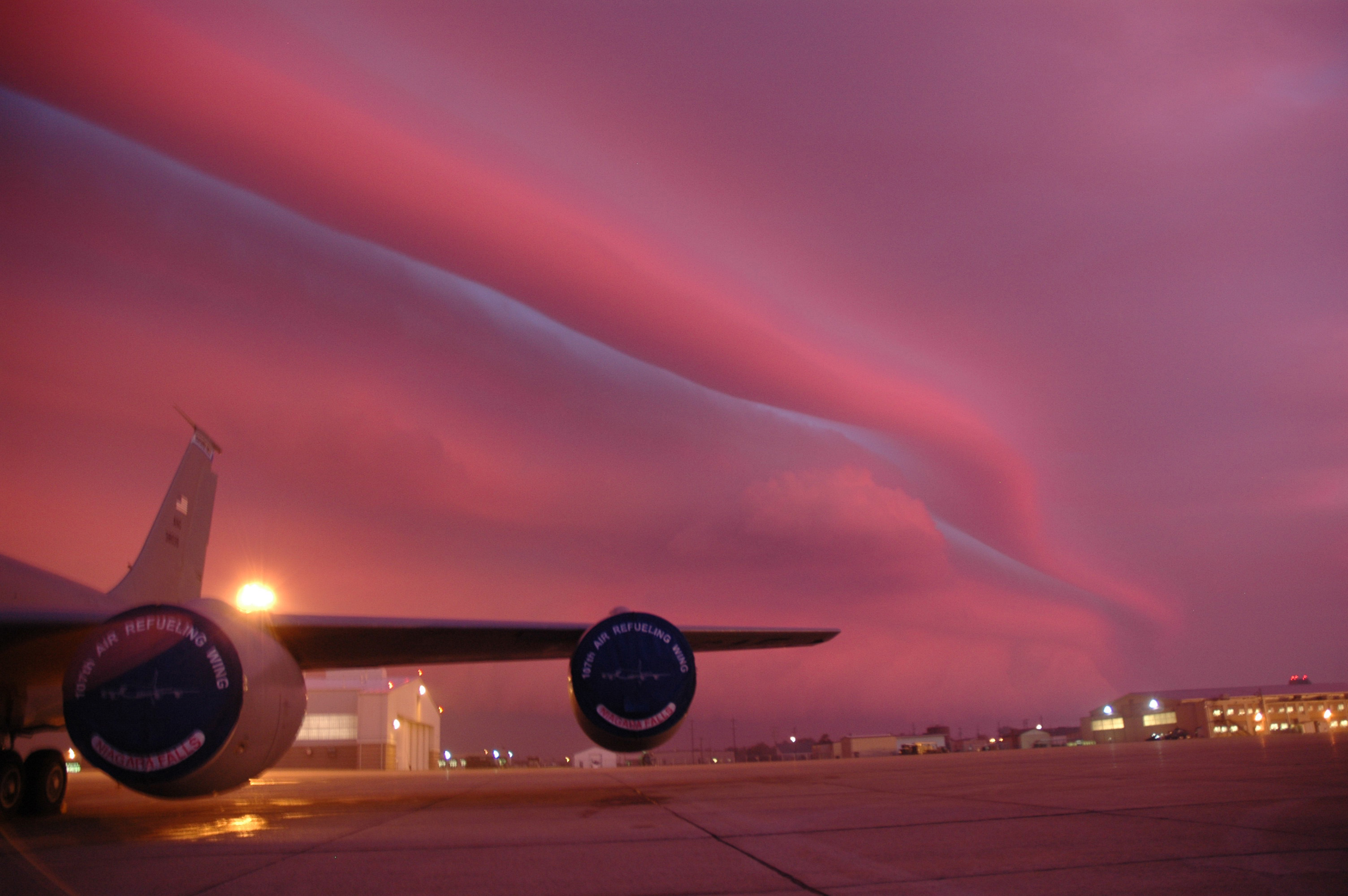
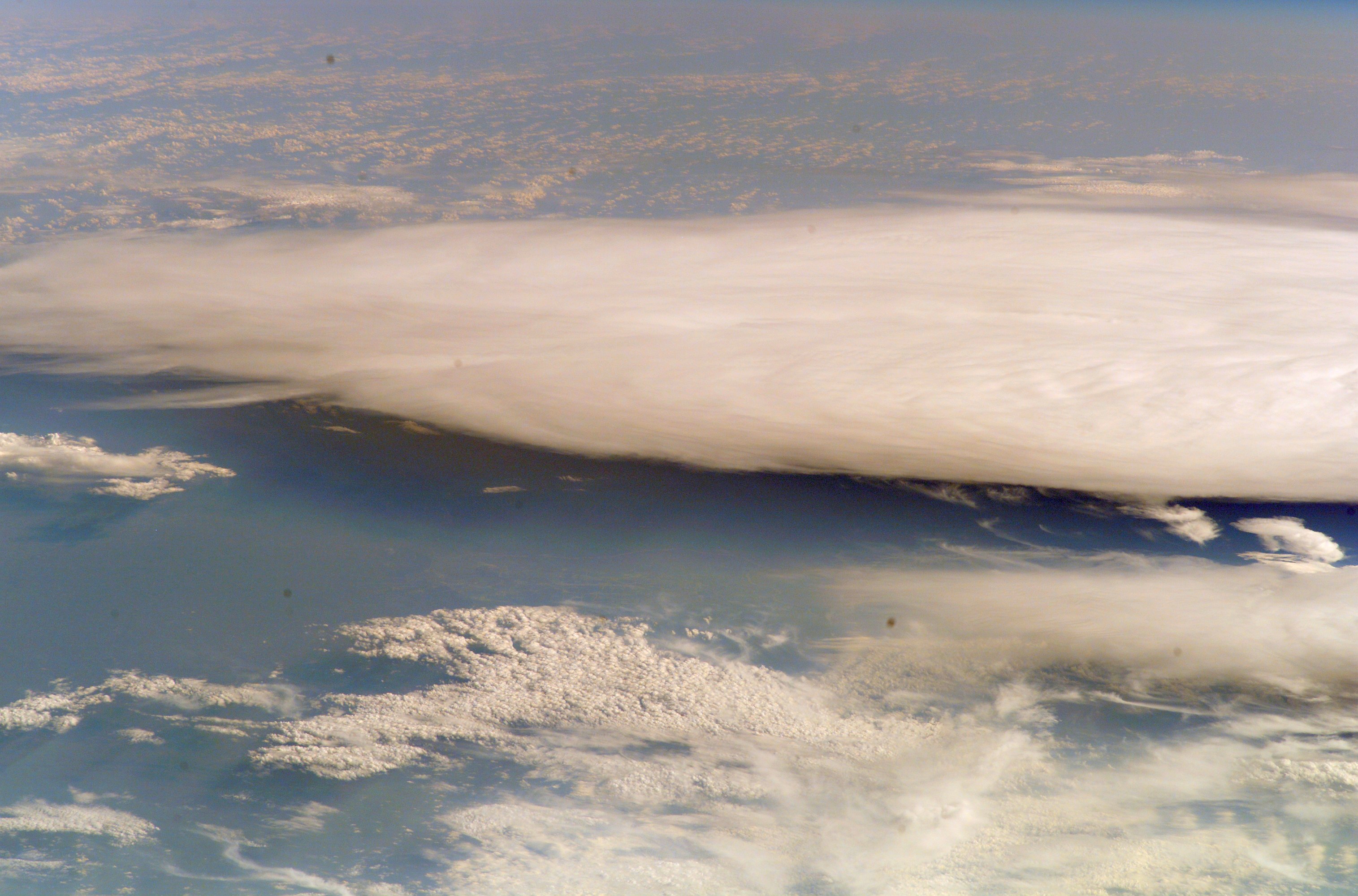
1. Beautiful and Impressive View of a Storm Front, With Clouds – One Shaped Like a Long Tube-Ribbon – and the
Sky Painted in a Wonderful Mixture of Pink-Purple Tints, October 4, 2006
Niagara Falls Air Reserve Station, State of New York, USA |
| |
Large Medium Original
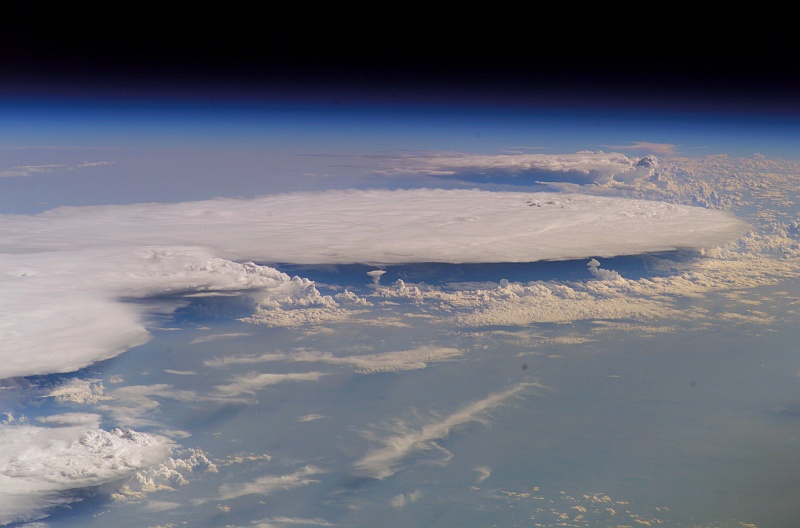
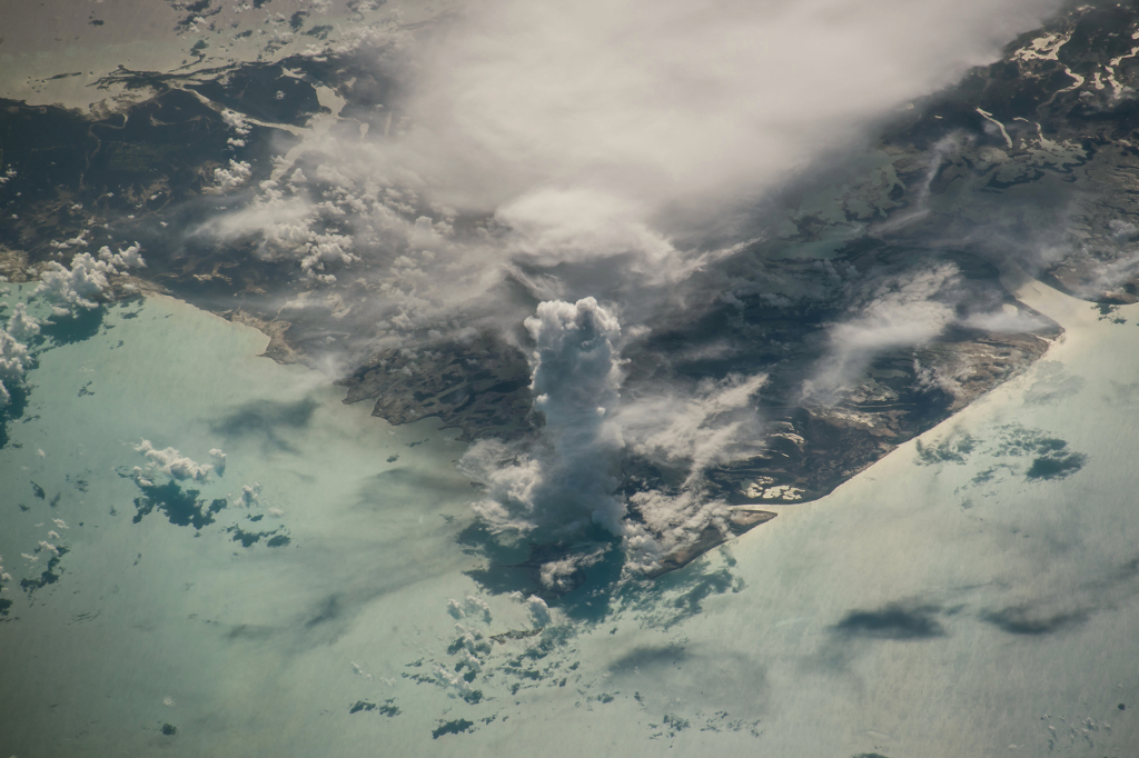
2. A Beautiful View of Huge Clouds Over Earth, August 20, 2007 at 22:17:35.634 GMT
As Seen From the International Space Station (Expedition 15)
Latitude (LAT): 51.3 · Longitude (LON): -94.1 · Altitude (ALT): 184 Nautical Miles · Sun Azimuth (AZI): 253° · Sun Elevation Angle (ELEV): 29° |
| |
August 20th, 2007 Photos Ordered By Time
(A) ISS015-E-23712, 22:17:20.559 GMT: Large, Medium, Original · (B) ISS015-E-23713, 22:17:22.841 GMT: Large, Medium, Original
(C) ISS015-E-23714, 22:17:25.085 GMT: Large, Medium, Original · (D) ISS015-E-23715, 22:17:27.421 GMT: Large, Medium, Original
(E) ISS015-E-23716, 22:17:35.634 GMT: Large, Medium, Original |
| |
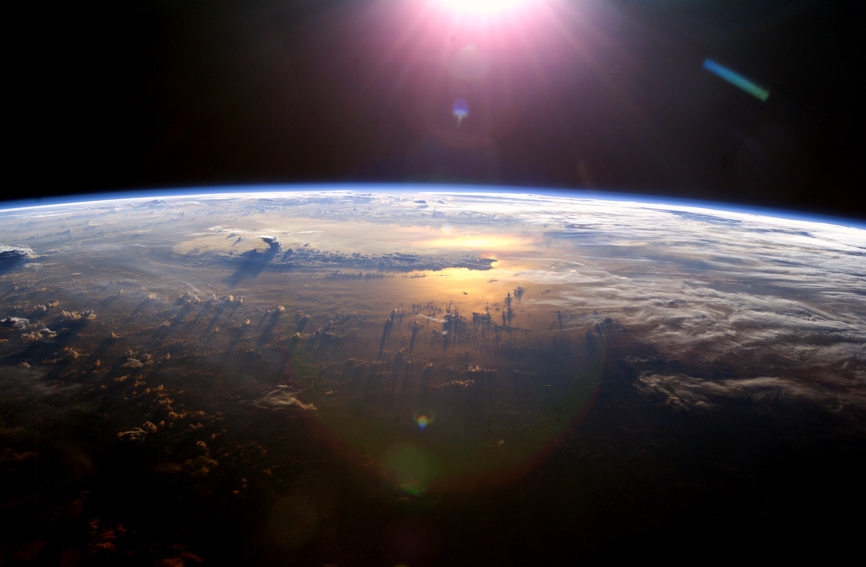
Seen From the International Space Station (Expedition 7) on July 21, 2003: Beautiful Pacific Ocean Sunset and Towering Thundercloud »
http://ChamorroBible.org/gpw/gpw-200702.htm » Photo 49 »
http://ChamorroBible.org/images/photos/gpw-200702-49-NASA-ISS007-E-10807-space-sunset-20030721-Pacific-Ocean-medium.jpg
http://ChamorroBible.org/images/photos/gpw-200702-49-NASA-ISS007-E-10807-space-sunset-20030721-Pacific-Ocean-large.jpg |
| |

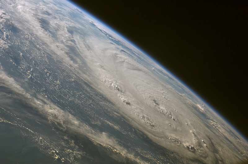
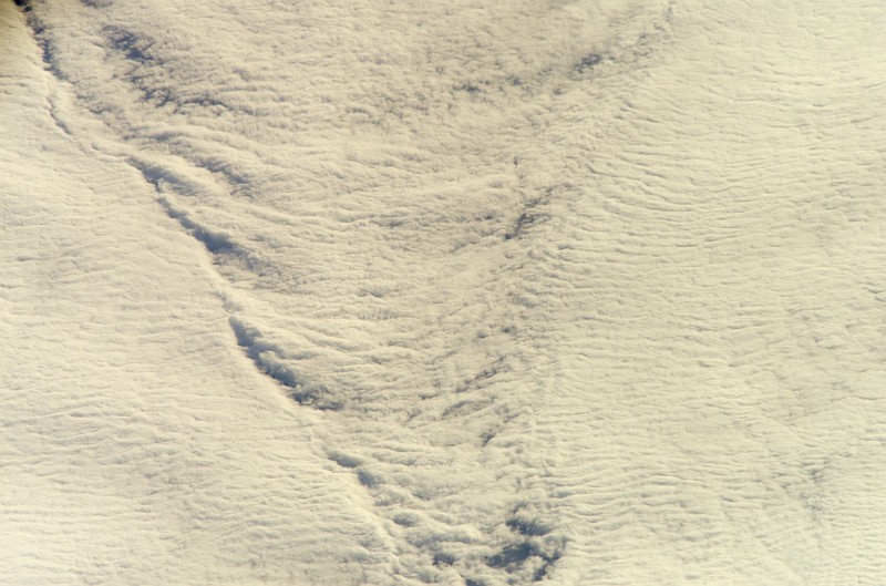
Large Medium Original
3. Hurricane Gordon Over the Atlantic Ocean, September 17, 2006 at 18:15:36 GMT
As Seen From Space Shuttle Atlantis (STS-115) |
| |
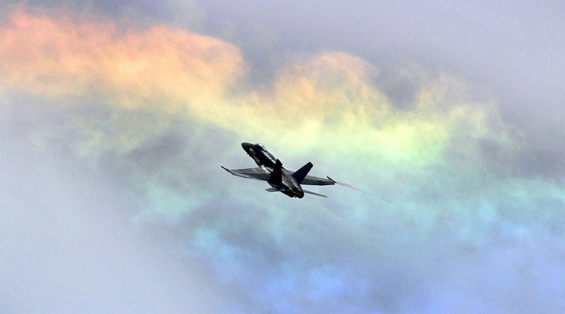
Large Medium Original
4. Rainbow-Colored Cloud, June 2, 2007
Norfolk, Commonwealth of Virginia, USA |
| |
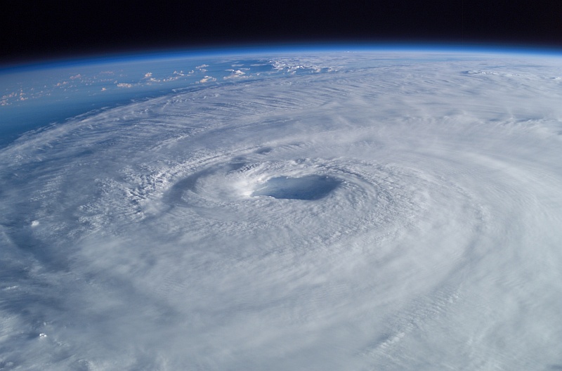
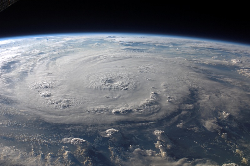
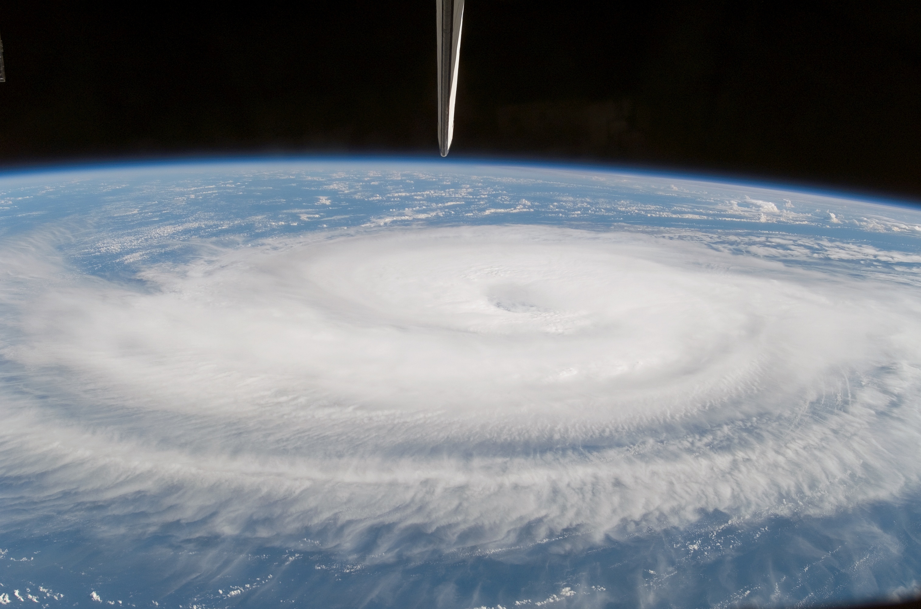
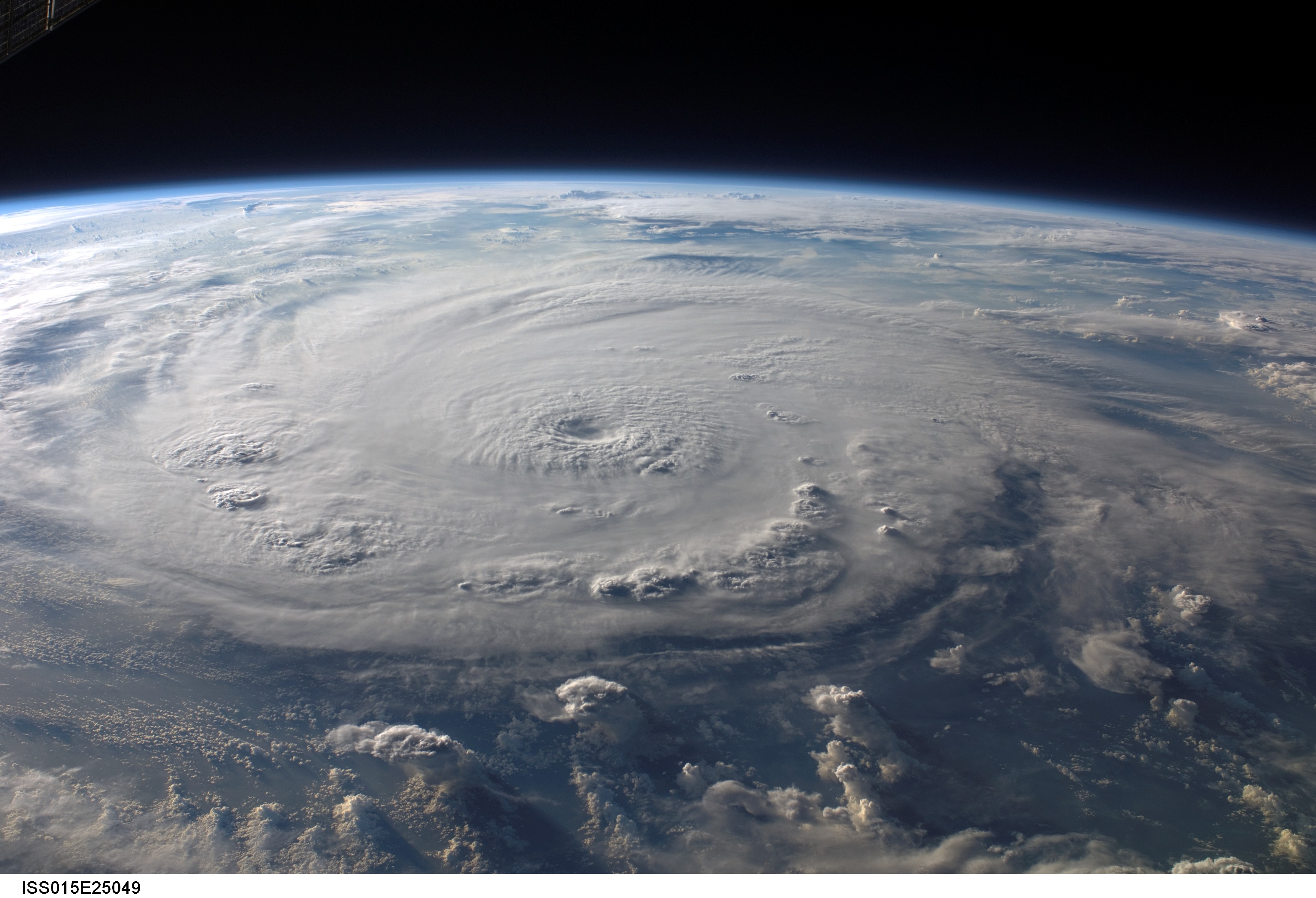
Large Medium Original
5. Hurricane Isabel Over the Atlantic Ocean, September 15, 2003 at 10:54:05.640 GMT
As Seen From the International Space Station (Expedition 7) |
| |
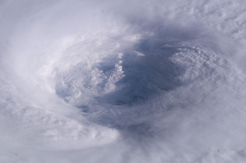
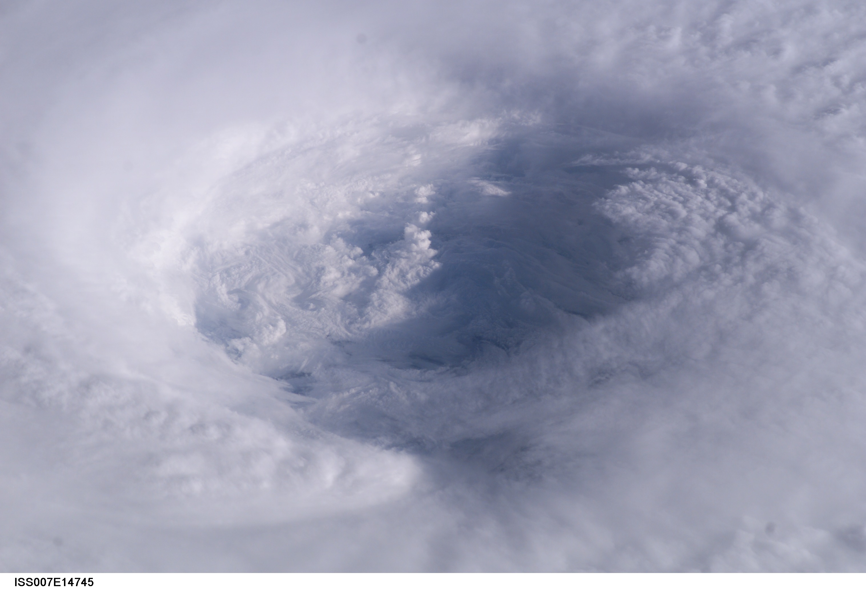
Large Medium Original
6. A Detailed View of Hurricane Isabel's Cloudy Eye, Over the Atlantic Ocean on September 13, 2003 at 11:18:44.230 GMT
As Seen From the International Space Station (Expedition 7) |
| |
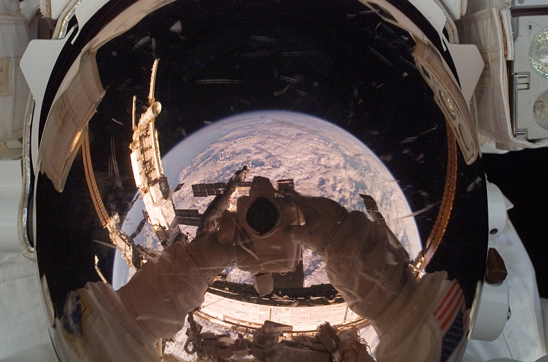
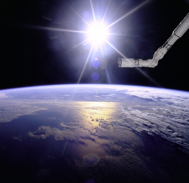
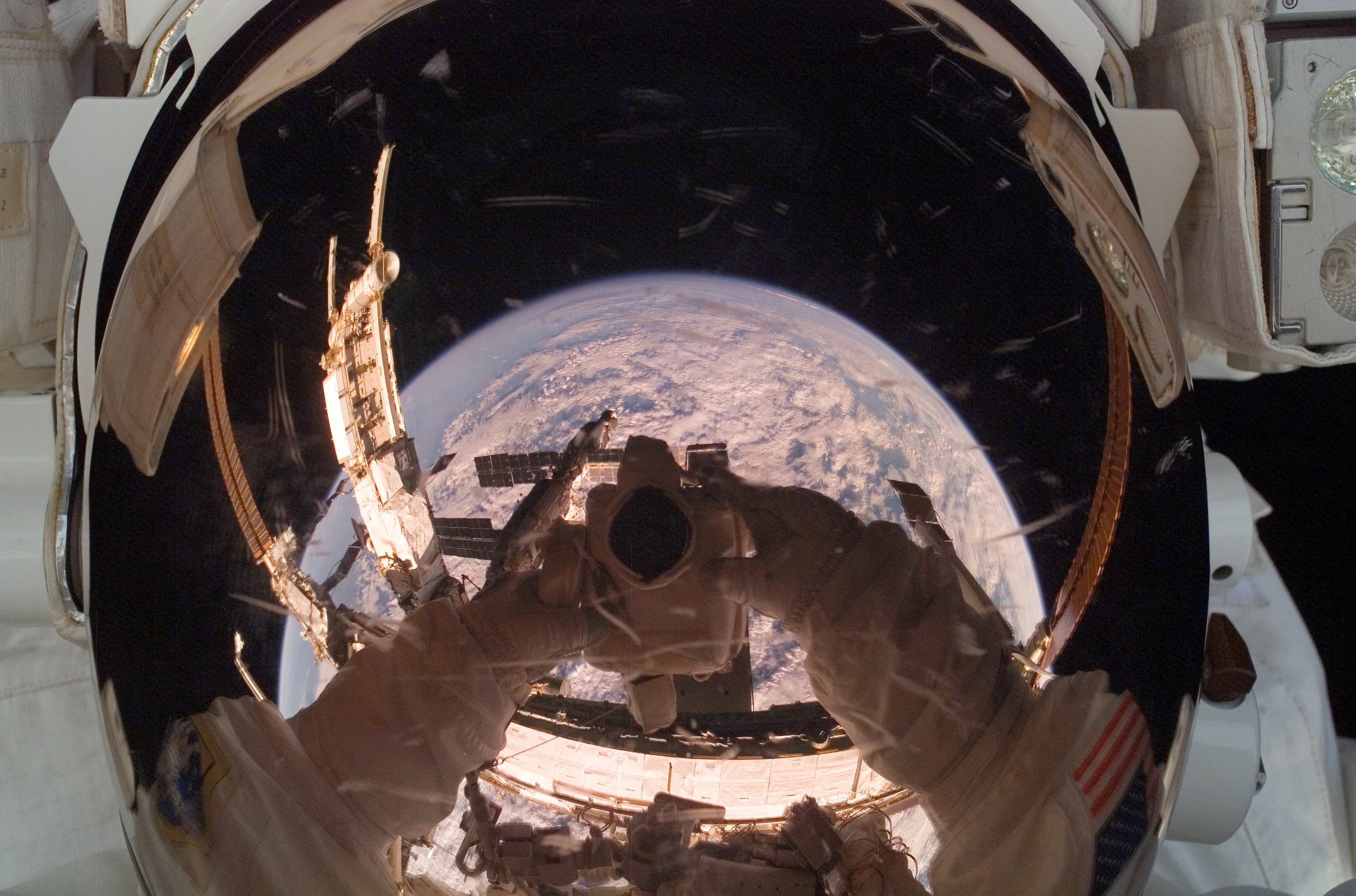
Large Medium Original
7. A Large Portion of Cloud-Covered Planet Earth Is Reflected In the Helmet Visor of NASA Astronaut Clayton C. Anderson, the
International Space Station (Expedition 15) Flight Engineer, August 15, 2007 |
| |
Large Medium Original
8. Hurricane Felix Over the Caribbean Sea, September 3, 2007 at 11:38:46.000 GMT
As Seen From the International Space Station (Expedition 15) |
| |
Large Medium Original
9. Another View of Destructive Hurricane Felix Over the Caribbean Sea, September 3, 2007 at 11:40:10.980 GMT
As Seen From the International Space Station (Expedition 15) |
| |
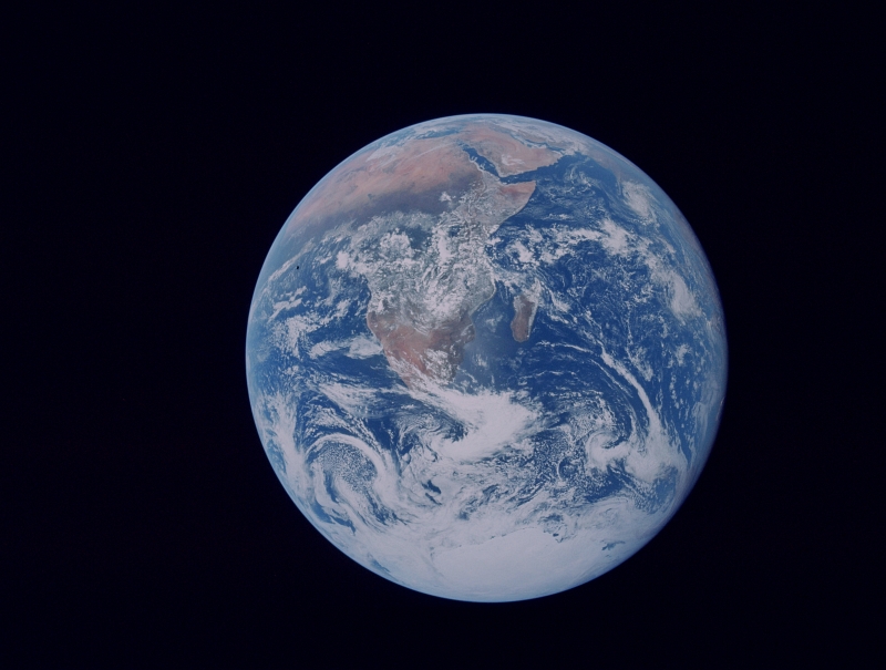
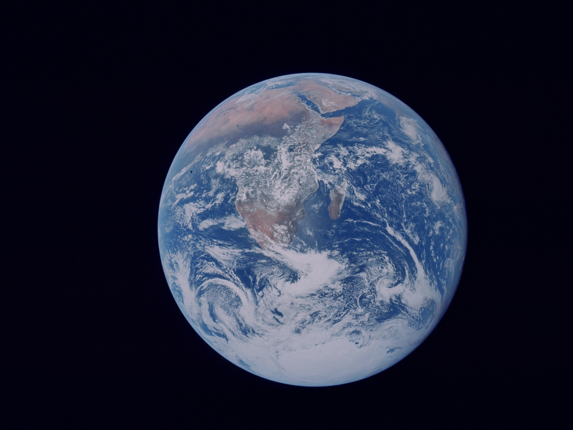
Large Medium Other Original
10. Heavy Cloud Over Earth's South Pole and the Southern Hemisphere, December 7, 1972
As Seen By NASA Apollo 17 Astronauts On Their Way to Earth's Moon |
| |
Large Medium Original
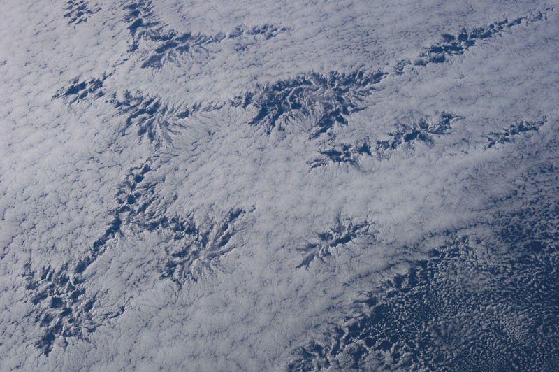
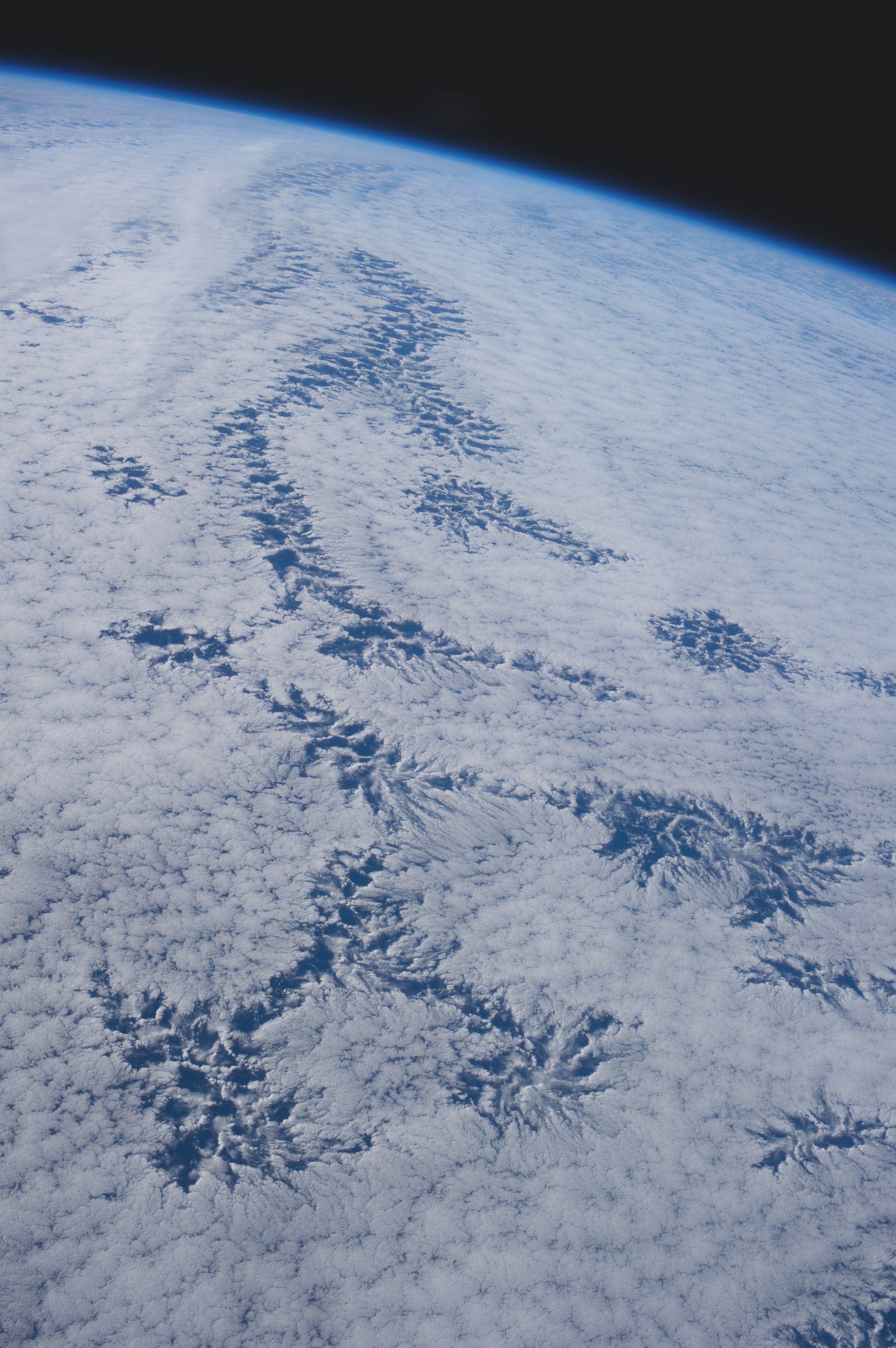
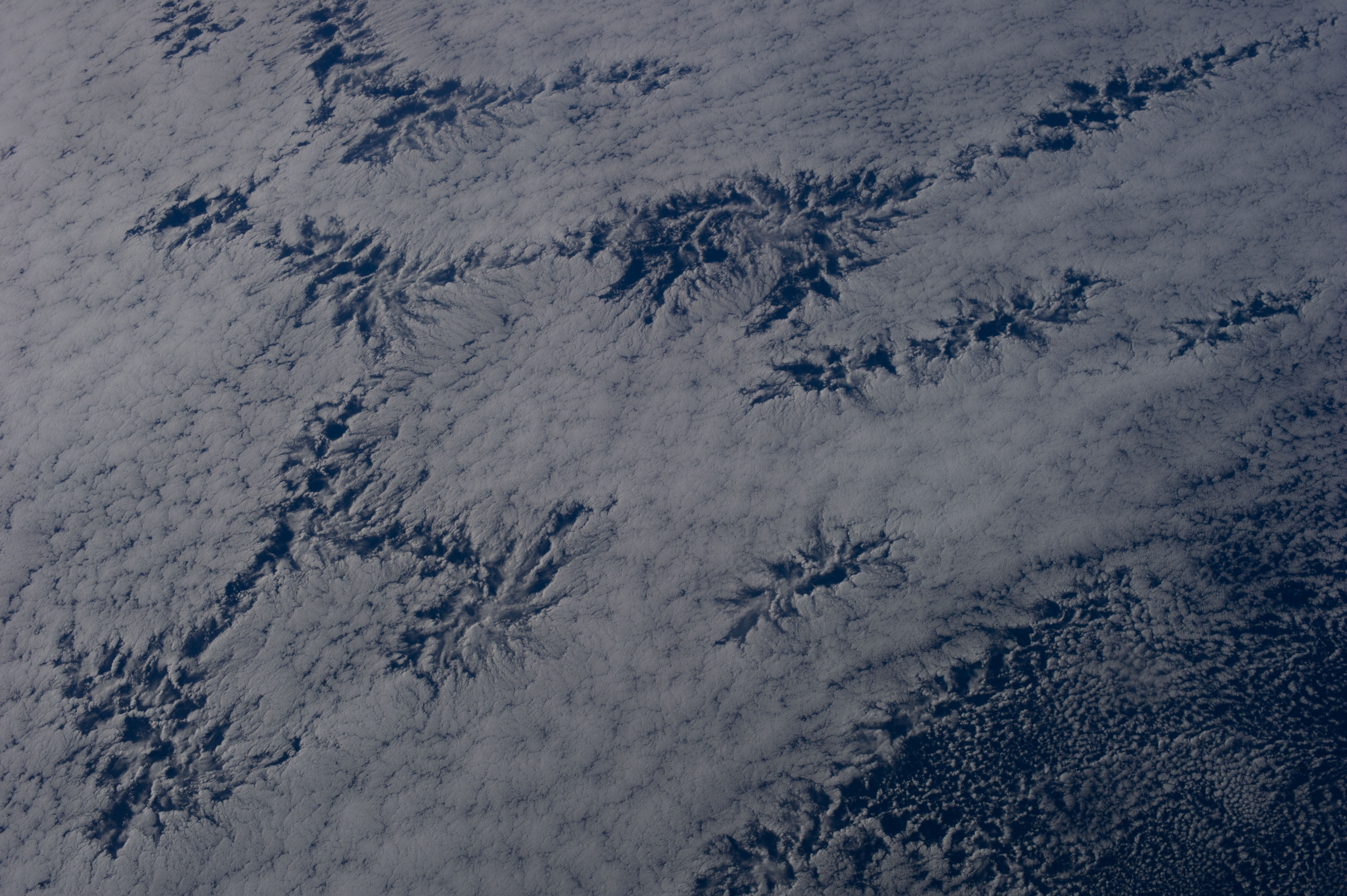
11. An Enormous Cloud Over the Pacific Ocean, Off the Coast of República de Chile – Republic of Chile, September 7, 2007 at 21:24:08.229 GMT
As Seen From the International Space Station (Expedition 15)
Latitude (LAT): -22.5 · Longitude (LON): -71.5 · Altitude (ALT): 187 Nautical Miles · Sun Azimuth (AZI): 284° · Sun Elevation Angle (ELEV): 16° |
| |
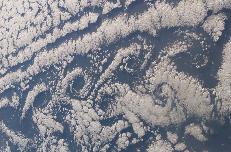
Large Medium Original
12. Spectacular von Karman Vortices Over the Atlantic Ocean, January 18, 2003 at 09:36:29.865 GMT
As Seen From Space Shuttle Columbia (STS-107) |
| |
|
http://MaartenRutgers.org » "Vortex streets behind cylinders" by Dr. Maarten A. Rutgers »
http://MaartenRutgers.org/science/street/right_cylinders.htm
http://MaartenRutgers.org/movie/ratchet.mov (video)
http://MaartenRutgers.org/movie/doubling-dots2.mov (video)
von Karman Vortices
Photo 10 and Photo 11 » http://ChamorroBible.org/gpw/gpw-20050129.htm
Photo 12 and Photo 13 » http://ChamorroBible.org/gpw/gpw-20061021.htm |
| |
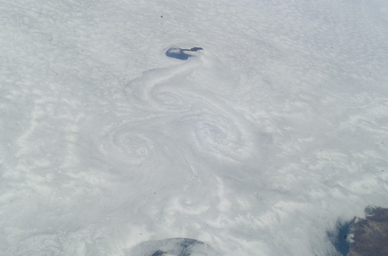
Large Medium Original
13. Total Cloud Cover and a von Karman Vortex Street, Guadalupe, Estados Unidos Mexicanos – United Mexican States
June 2, 2003 at 22:24:35.342 GMT
As Seen From the International Space Station (Expedition 7) |
| |
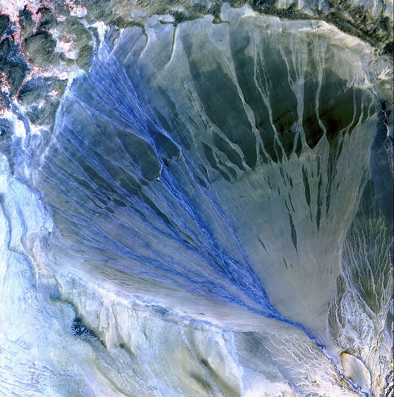
Large Medium Original
14. A Beautiful Alluvial Fan, With the River Branching Into Many Streams of Flowing Blue Water, Between the Kunlun Mountains and
Altun Mountains, May 2, 2002, Xinjiang Province, Zhonghua Renmin Gongheguo – People's Republic of China
As Seen By the ASTER Instrument Aboard NASA's Terra Satellite |
| |
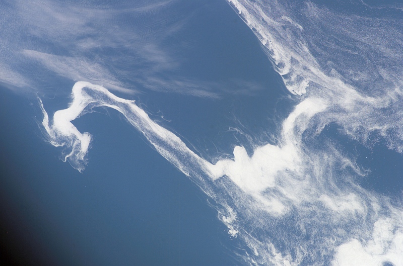
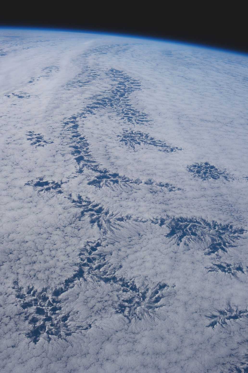
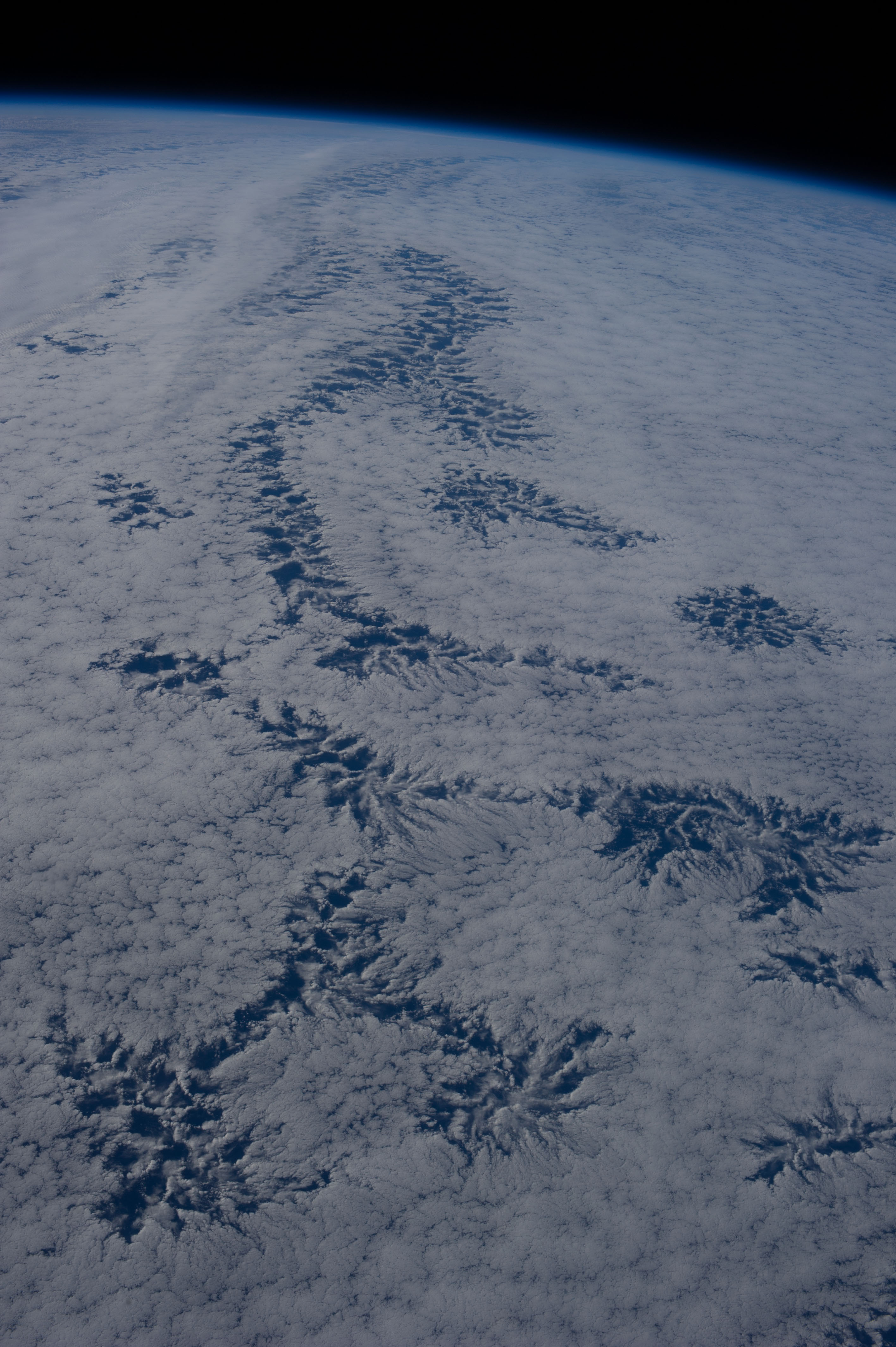
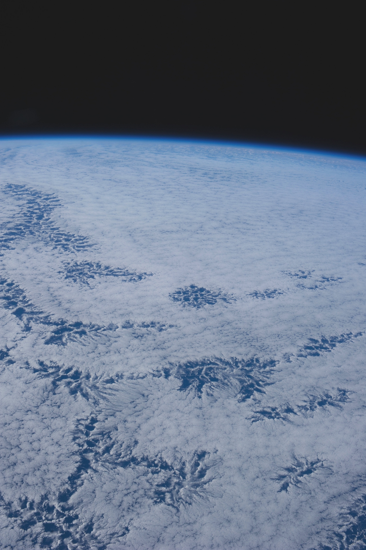
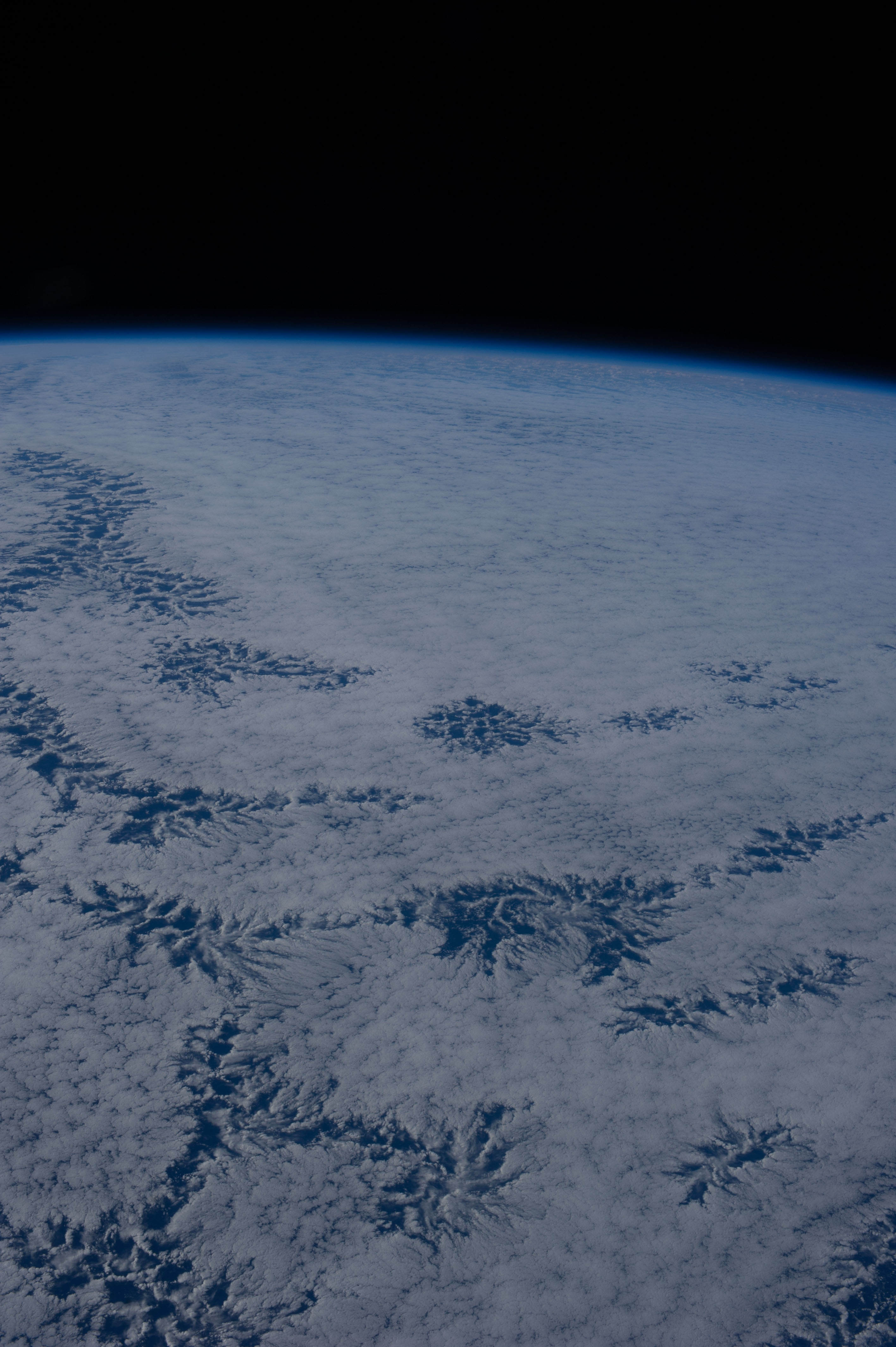
Large Medium Original
15. Wake Pattern In the Stratus Clouds Over the Pacific Ocean, September 8, 2007 at 21:12:12.145 GMT
As Seen From the International Space Station (Expedition 15) |
| |
Large Medium Original
16. Very Big, Very Bright Cloud Over the Gulf of Mexico, October 8, 2007 at 22:17:44.585 GMT
As Seen From the International Space Station (Expedition 15)
Latitude (LAT): 29.5 · Longitude (LON): -88.0 · Altitude (ALT): 183 Nautical Miles · Sun Azimuth (AZI): 254° · Sun Elevation Angle (ELEV): 15° |
| |
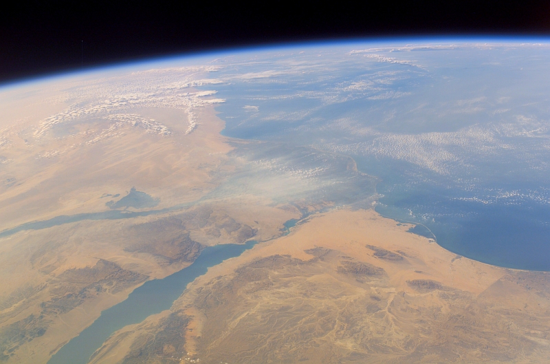
Large Medium Original
17. Beautiful View of Clouds Over North Africa and the Mediterranean Sea, and a Scenic View of the Nile River, the Nile River Delta, Gulf of Suez,
and Part of the Sinai Peninsula in Jumhuriyat Misr al-Arabiyah – Arab Republic of Egypt,
October 11, 2007 at 12:42:24.672 GMT As Seen From the International Space Station (Expedition 15)
Latitude (LAT): 29.0 · Longitude (LON): 39.4 · Altitude (ALT): 182 Nautical Miles · Sun Azimuth (AZI): 244° · Sun Elevation Angle (ELEV): 27° |
| |
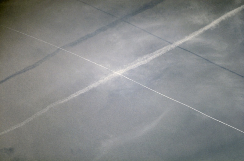
Large Medium Original
18. Two Contrails and Their Shadows Over the Western Pacific Ocean, June 27, 2007 at 01:14:38.440 GMT
As Seen From the International Space Station (Expedition 15)
Latitude (LAT): 3.3 · Longitude (LON): 122.1 · Altitude (ALT): 178 Nautical Miles · Sun Azimuth (AZI): 59° · Sun Elevation Angle (ELEV): 46° |
| |

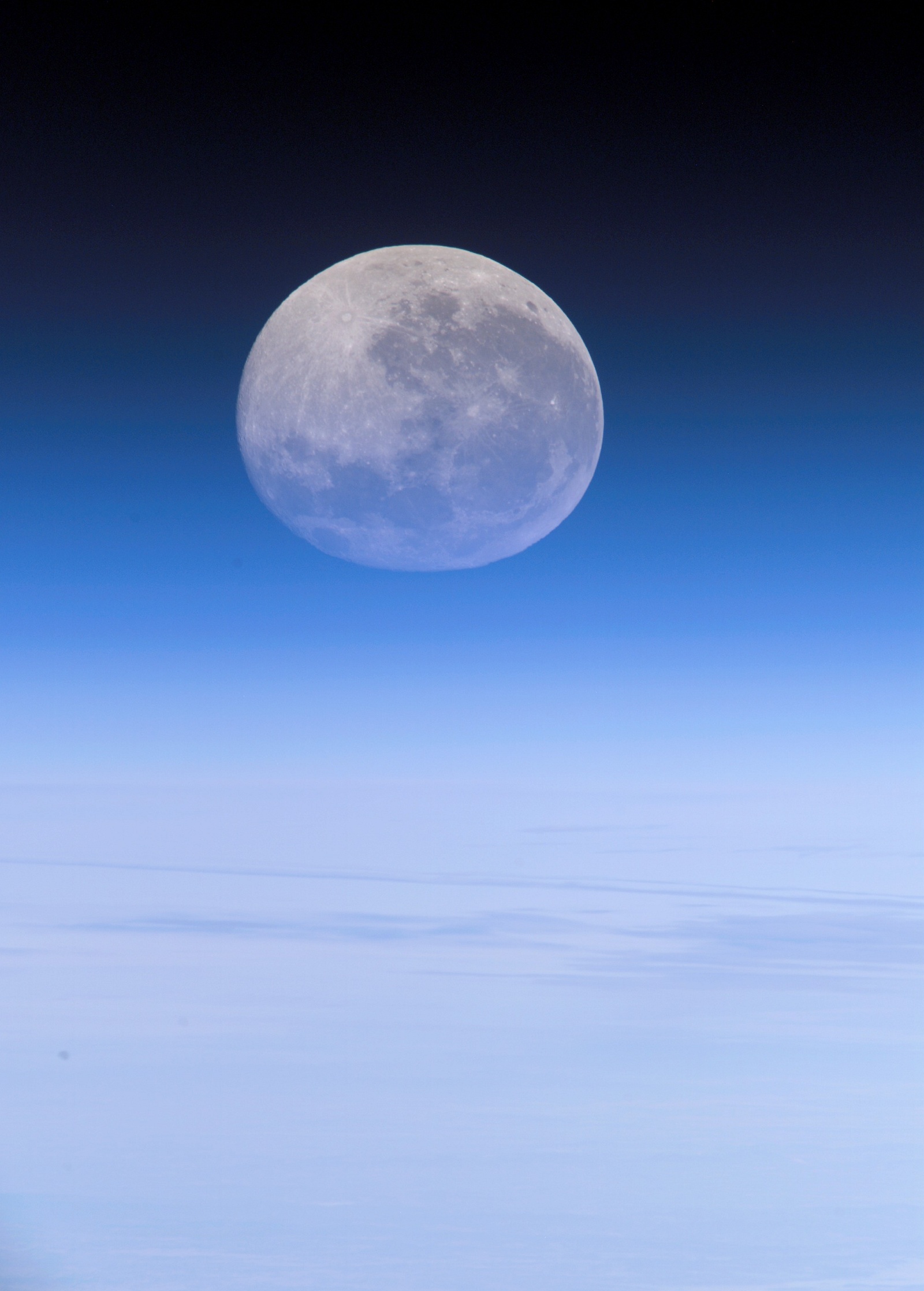
Large Medium Original
19. Over the Pacific Ocean, Earth's Moon Viewed Through and Above Earth's Blue Atmospheric Limb, July 30, 2007 at 21:37:34.746 GMT
As Seen From the International Space Station (Expedition 15)
Latitude (LAT): -23.9 · Longitude (LON): 165.9 · Altitude (ALT): 183 Nautical Miles · Sun Azimuth (AZI): 55° · Sun Elevation Angle (ELEV): 25° |
| |

Large Medium Original
20. The Powerful Influence of Hurricane Noel: Heavy Cloud Clover Over the Atlantic Coast of Florida, USA, November 2, 2007
As Seen From Space Shuttle Discovery (STS-120) |
| |
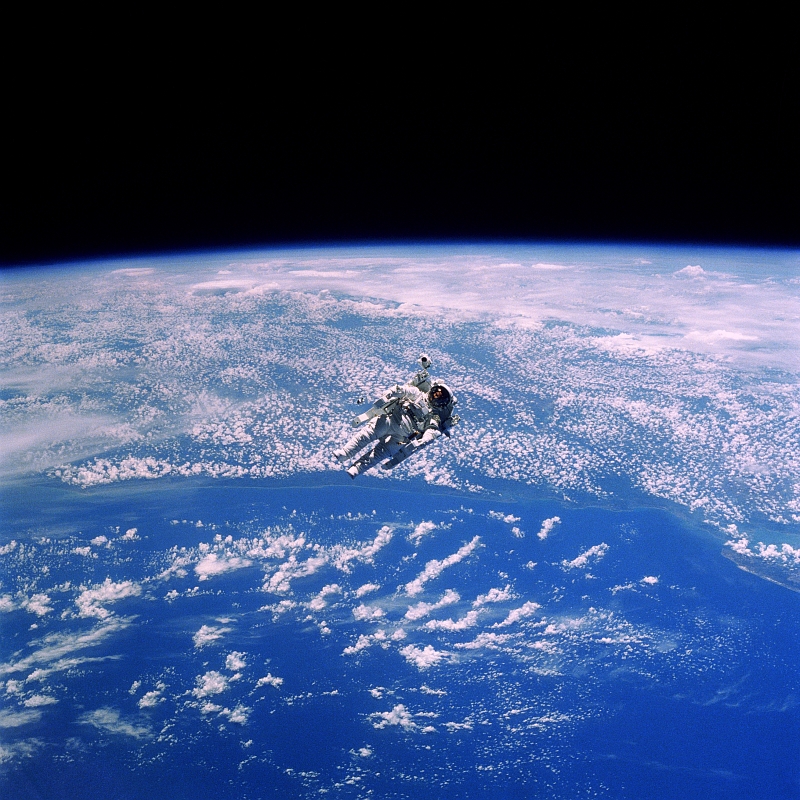
Large Medium Original
21. NASA Astronaut Robert L. Stewart Floats Above Cloudy Earth During an Untethered Extravehicular Activity (EVA) , February 1984
As Seen From Space Shuttle Challenger (STS-41B) |
| |
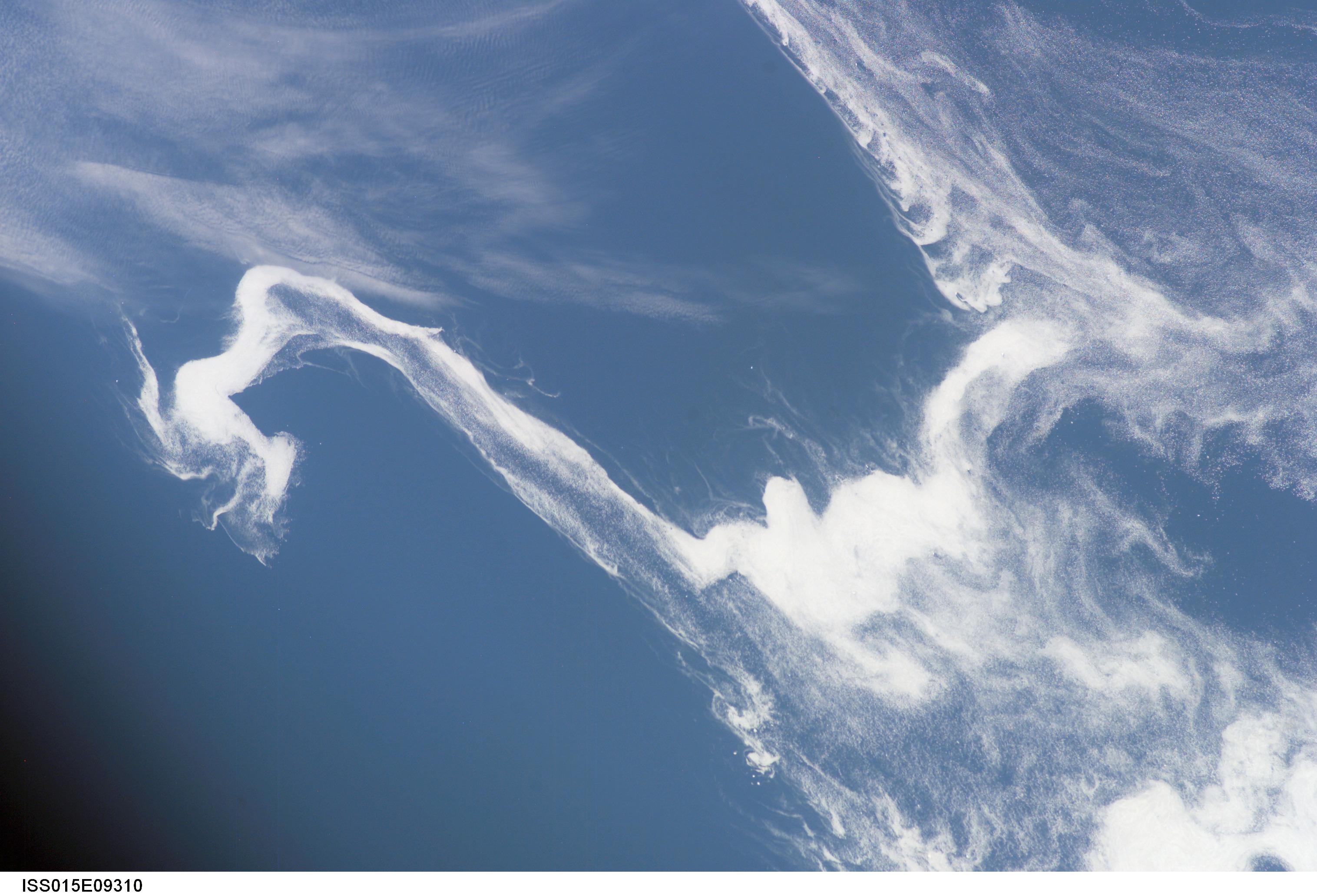
Large Medium Original
22. Ice Flows In the Labrador Sea, May 24, 2007 at 10:43:48.203 GMT
As Seen From the International Space Station (Expedition 15)
Latitude (LAT): 46.8 · Longitude (LON): -53.0 · Altitude (ALT): 179 Nautical Miles · Sun Azimuth (AZI): 88° · Sun Elevation Angle (ELEV): 28° |
| |
Large Medium
23. Brilliant Sunburst Over Earth, May 1996
As Seen From Space Shuttle Endeavour (STS-77) |
| |
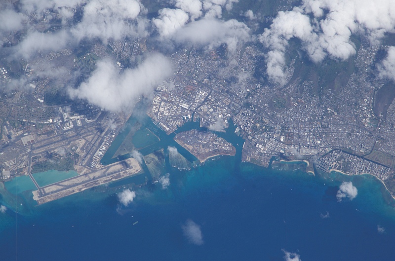
Large Medium Original
24. Clouds Over Oahu, State of Hawaii, USA, October 8, 2003
As Seen From the International Space Station (Expedition 7) |
| |

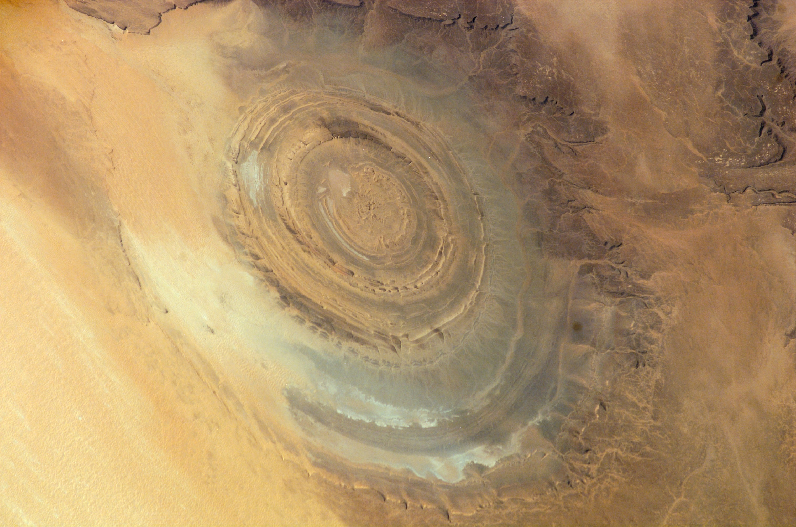
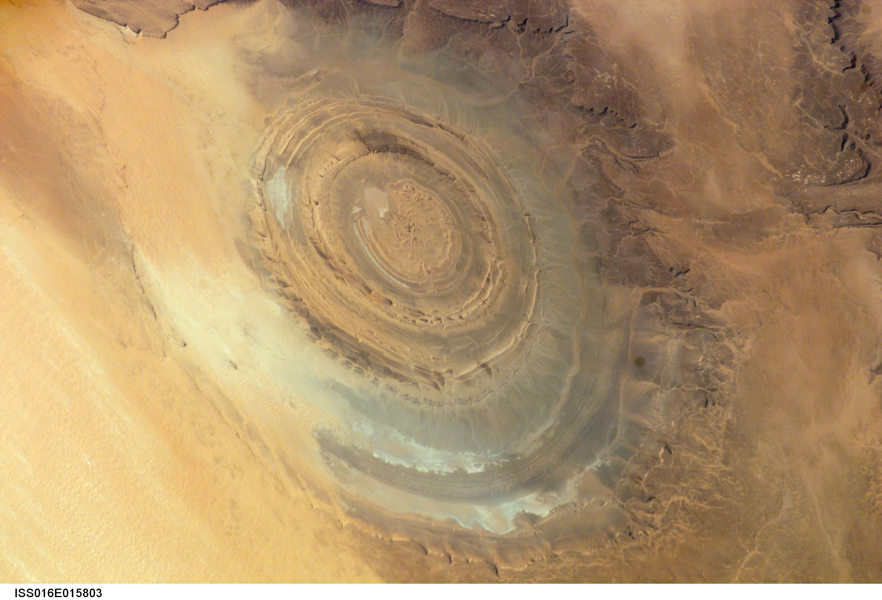
Large Medium Original
25. Richat Structure, the Beautiful, Circular Geological Formation Within Mauritania's Gres de Chinguetti Plateau, December 10, 2007
Maur Adrar Desert, Al Jumhuriyah al Islamiyah al Muritaniyah – Islamic Republic of Mauritania
As Seen From the International Space Station (Expedition 16) |
| |
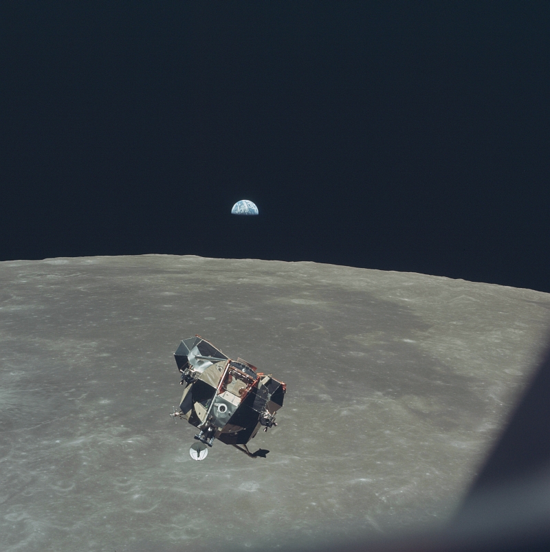
Large Medium Original
26. Beautiful Half-Illuminated Earth Backdrops the Liftoff of the NASA Apollo 11 Lunar Module ("Eagle") From the Moon's Surface, July 21, 1969
As Seen From the Orbiting NASA Apollo 11 Command and Service Modules ("Columbia") |
| |
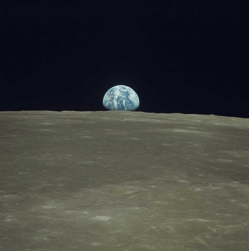
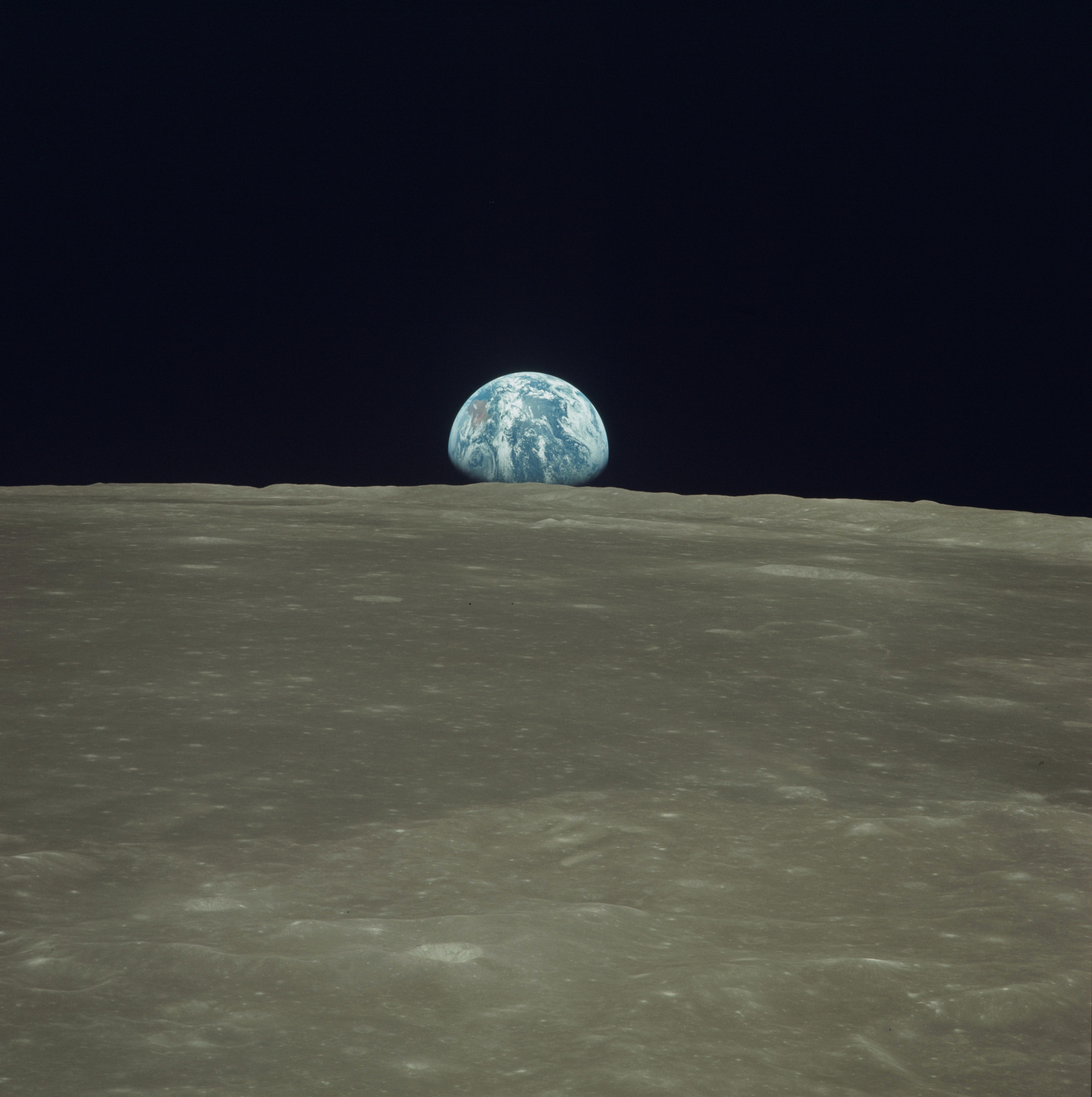
Large Medium Original
27. Earth Rises Over the Moon's Horizon, July 20, 1969
As Seen From the NASA Apollo 11 Spacecraft |
| |
Large Medium Original
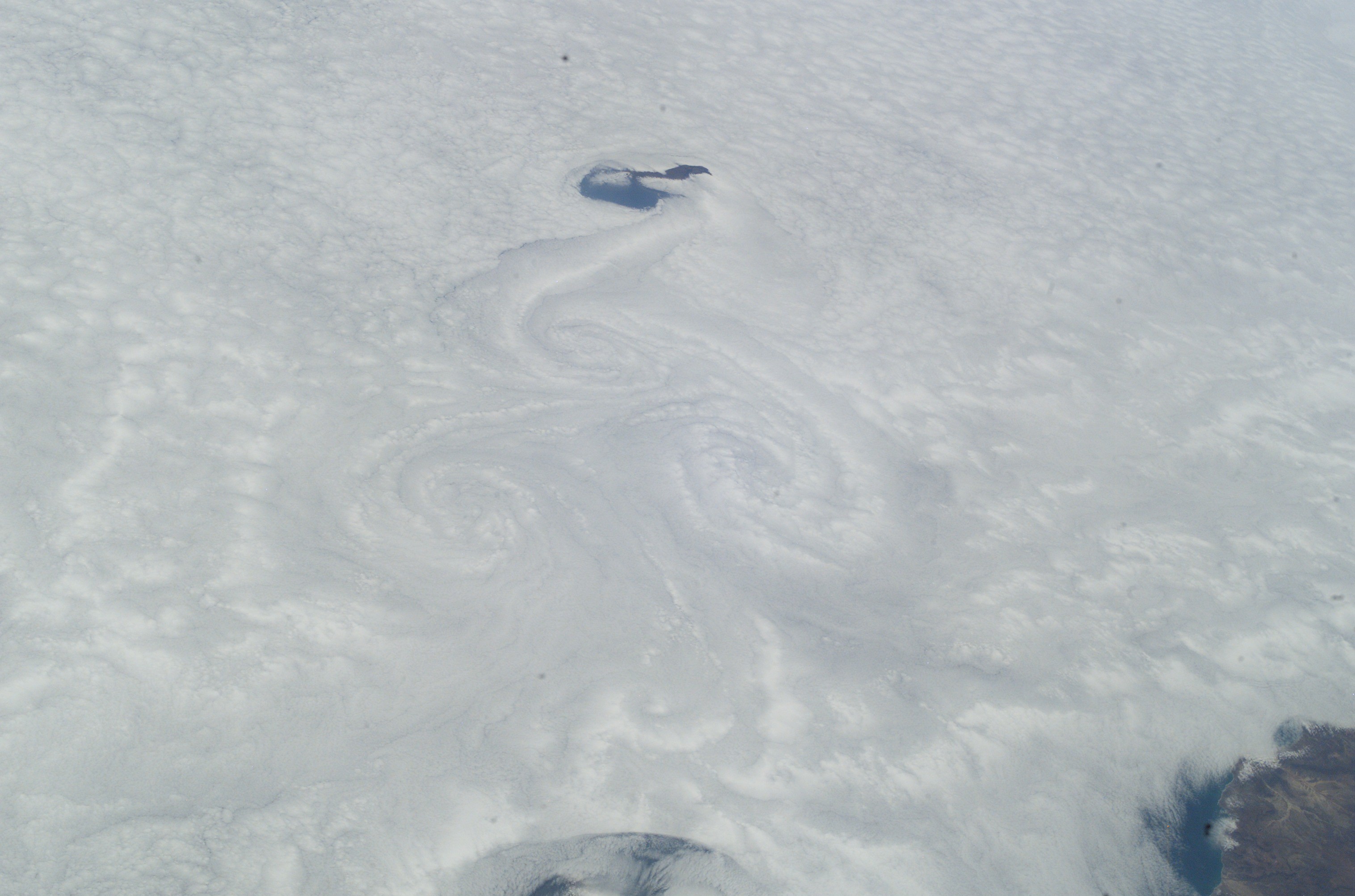
28. Cloud Circulation (Weak Low Pressure System) Near the Massa River Just South of Agadir, June 26, 2007 at 11:43:02 GMT
Off the Coast of Al Mamlakah al Maghribiyah – Kingdom of Morocco
As Seen From the International Space Station (Expedition 15) |
| |
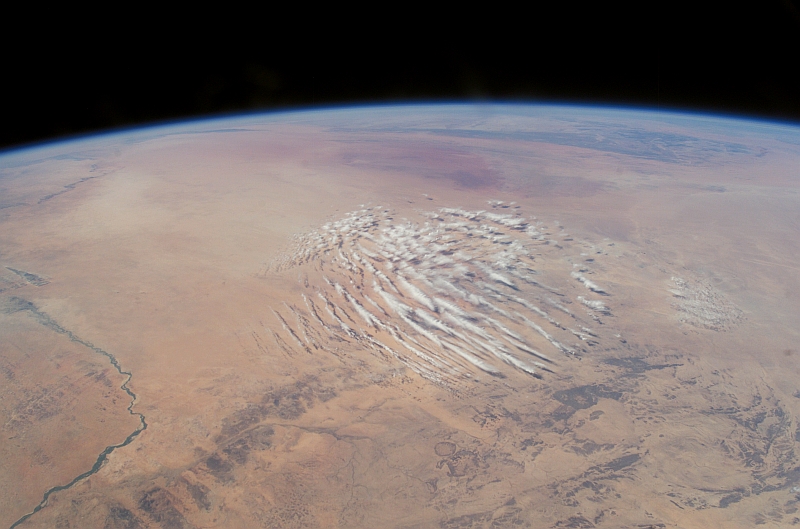
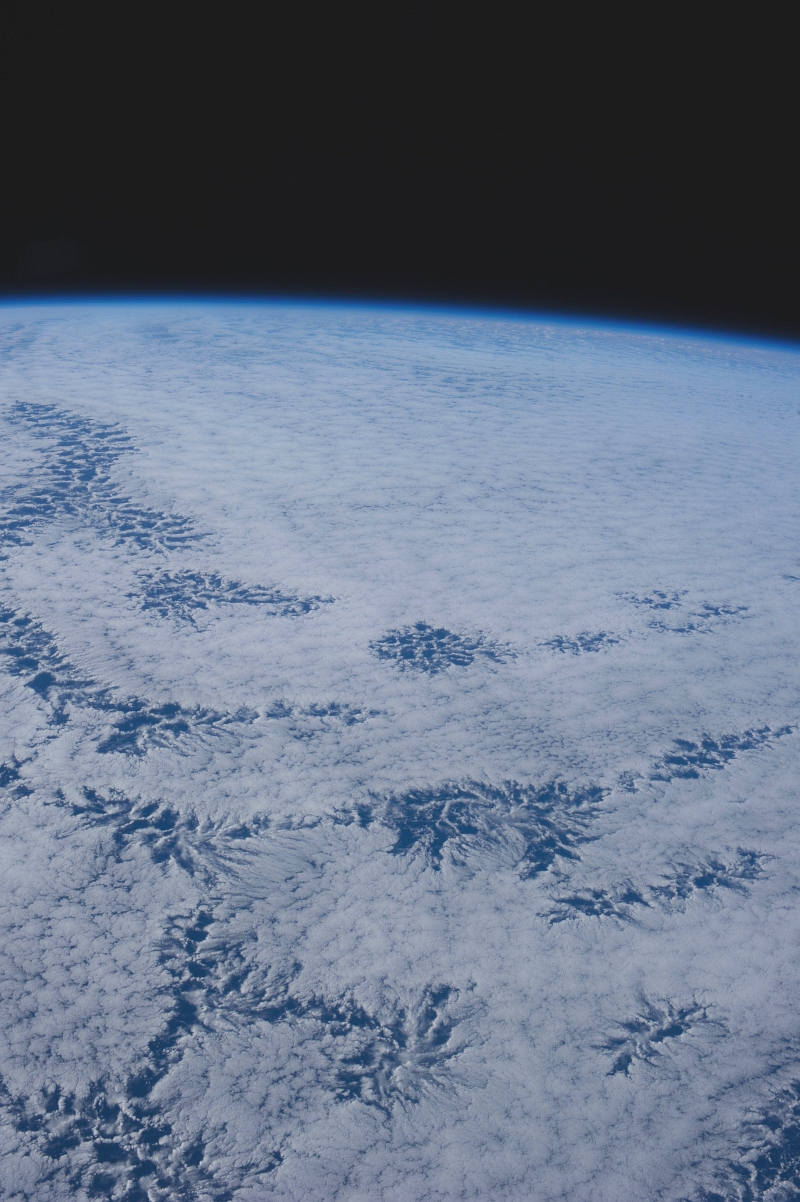
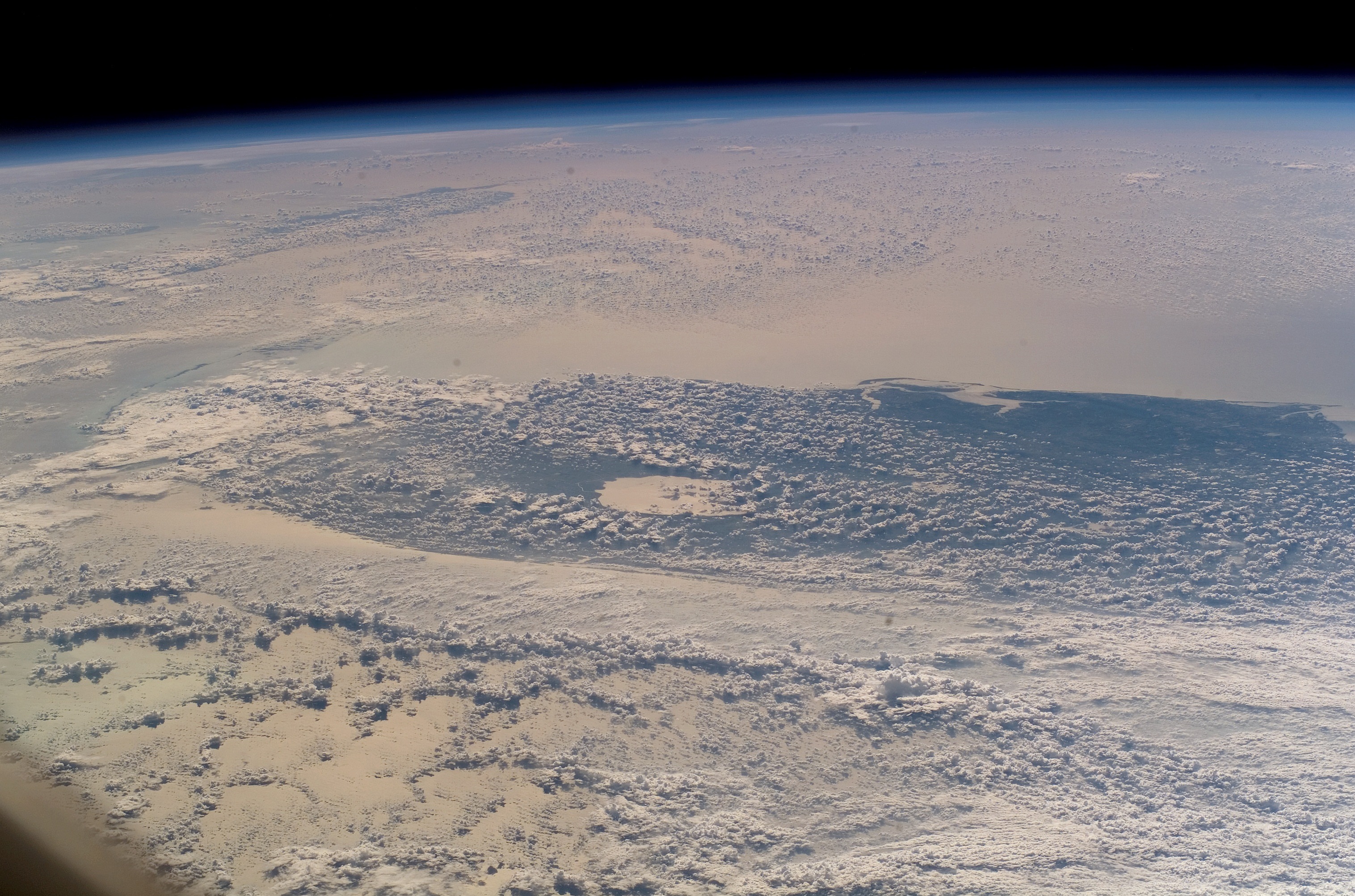
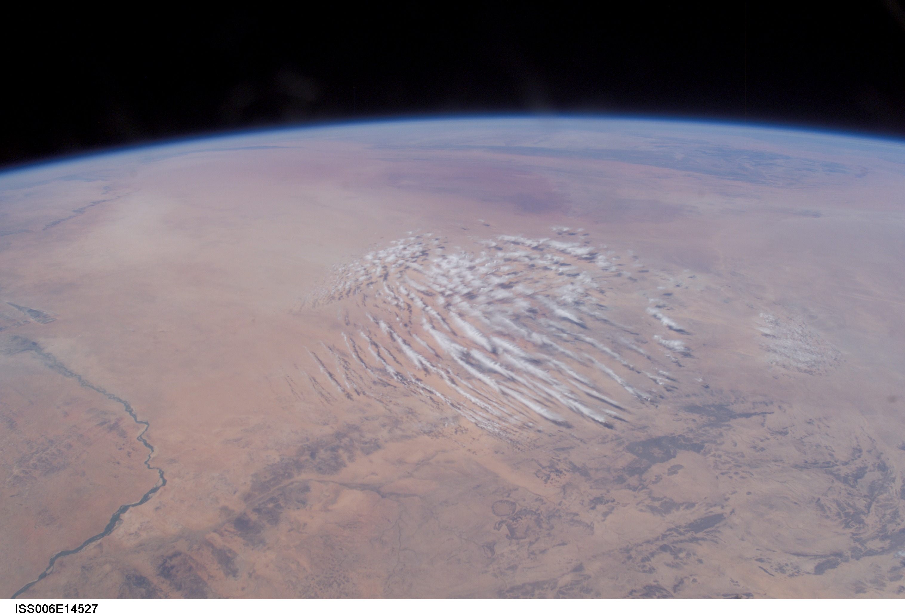
Large Medium Other Original
29. Cloud Pattern Over the Sahara, January 3, 2003 at 12:27:46.695 GMT
République du Mali – Republic of Mali
As Seen From the International Space Station (Expedition 6)
Latitude (LAT): 17.3 · Longitude (LON): 3.6 · Altitude (ALT): 212 Nautical Miles · Sun Azimuth (AZI): 193° · Sun Elevation Angle (ELEV): 49° |
| |
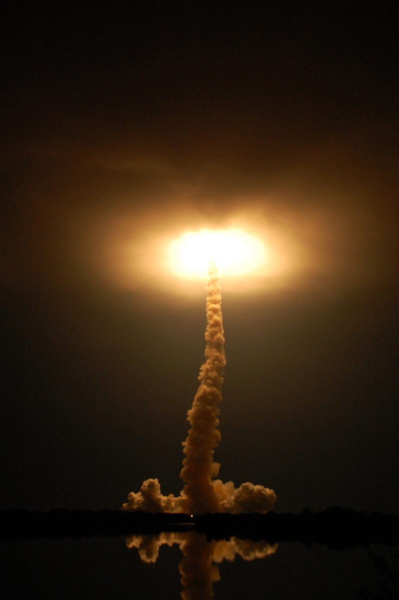
Large Medium Original
30. Space Shuttle Endeavour (STS-123) Lights Up the Clouds, March 11, 2008
2:28 a.m. EDT – 06:28 GMT
NASA John F. Kennedy Space Center, State of Florida, USA |
| |
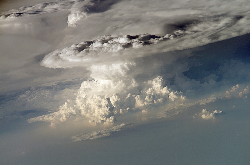
Large Medium Original
31. Cumulonimbus Clouds and Anvils Over Canada, North America on August 19, 2003 at 18:13:39.563 GMT
As Seen From the International Space Station (Expedition 7)
Latitude (LAT): 49.6 · Longitude (LON): -113.1 · Altitude (ALT): 202 Nautical Miles · Sun Azimuth (AZI): 148° · Sun Elevation Angle (ELEV): 50° |
| |
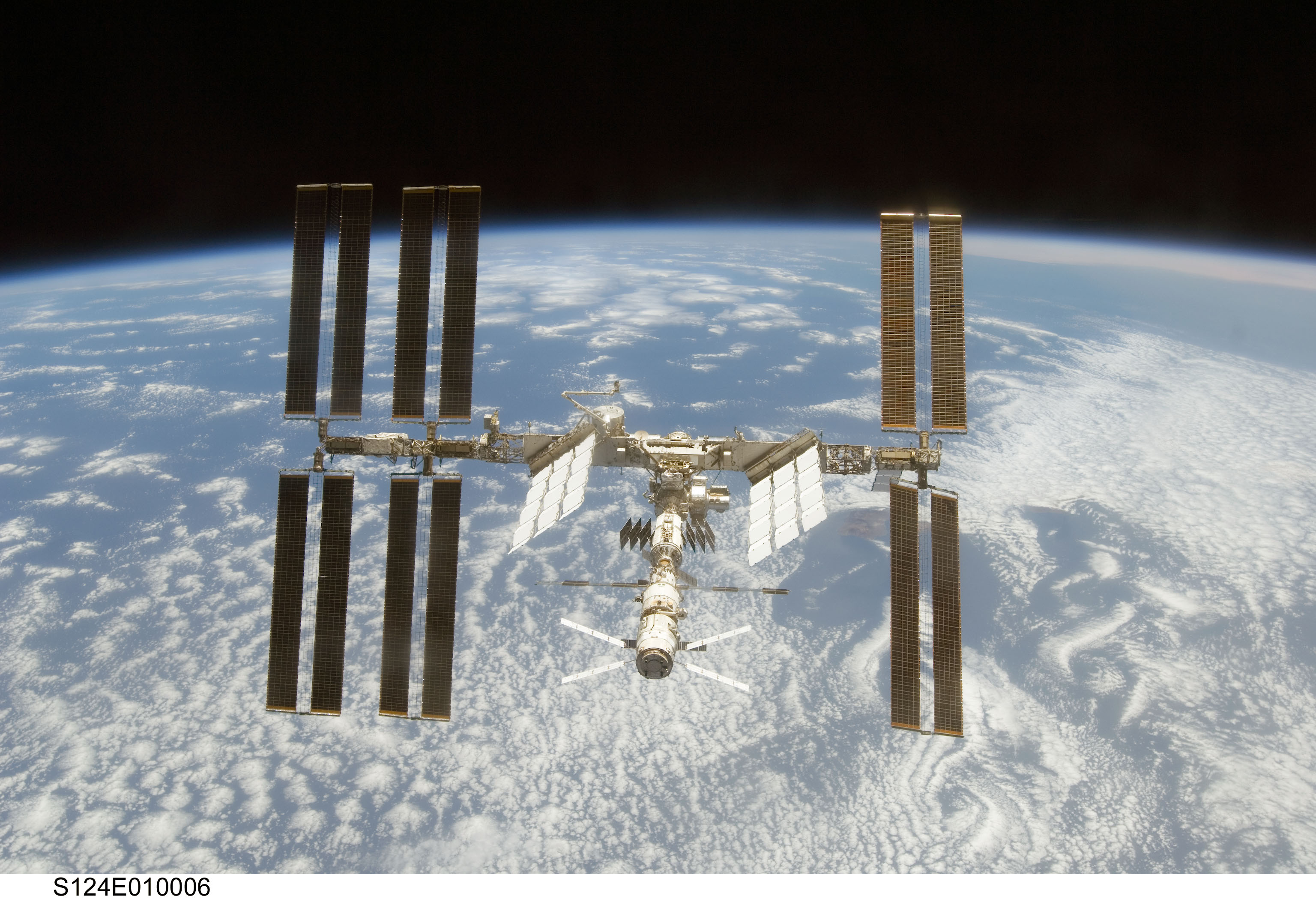
Large Medium Other Original
32. A Beautiful View of the Blackness of Space, Earth's Horizon, White Cloud Formations, Blue Water, and the
International Space Station Orbiting Over Planet Earth, June 11, 2008
As Seen From Space Shuttle Discovery (STS-124) |
| |
Large Medium Other Original
33. Another Spectacular View of the Blackness of Space, Earth's Horizon, White Cloud Formations, Blue Water, and the
International Space Station Orbiting Over Planet Earth, June 11, 2008
As Seen From Space Shuttle Discovery (STS-124) |
| |
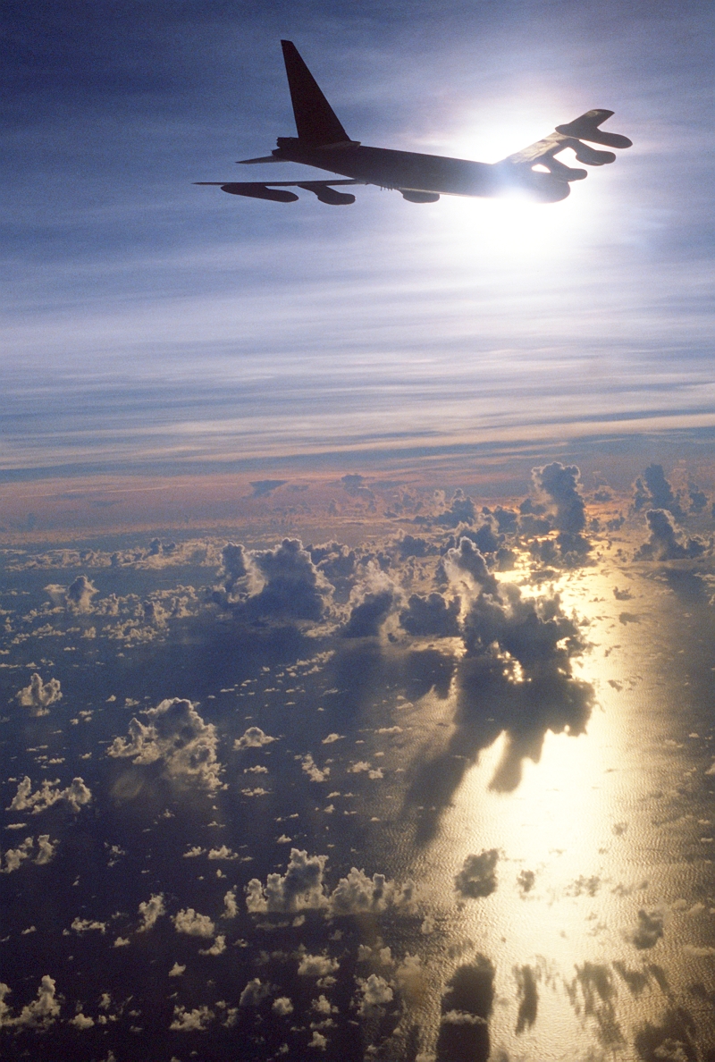
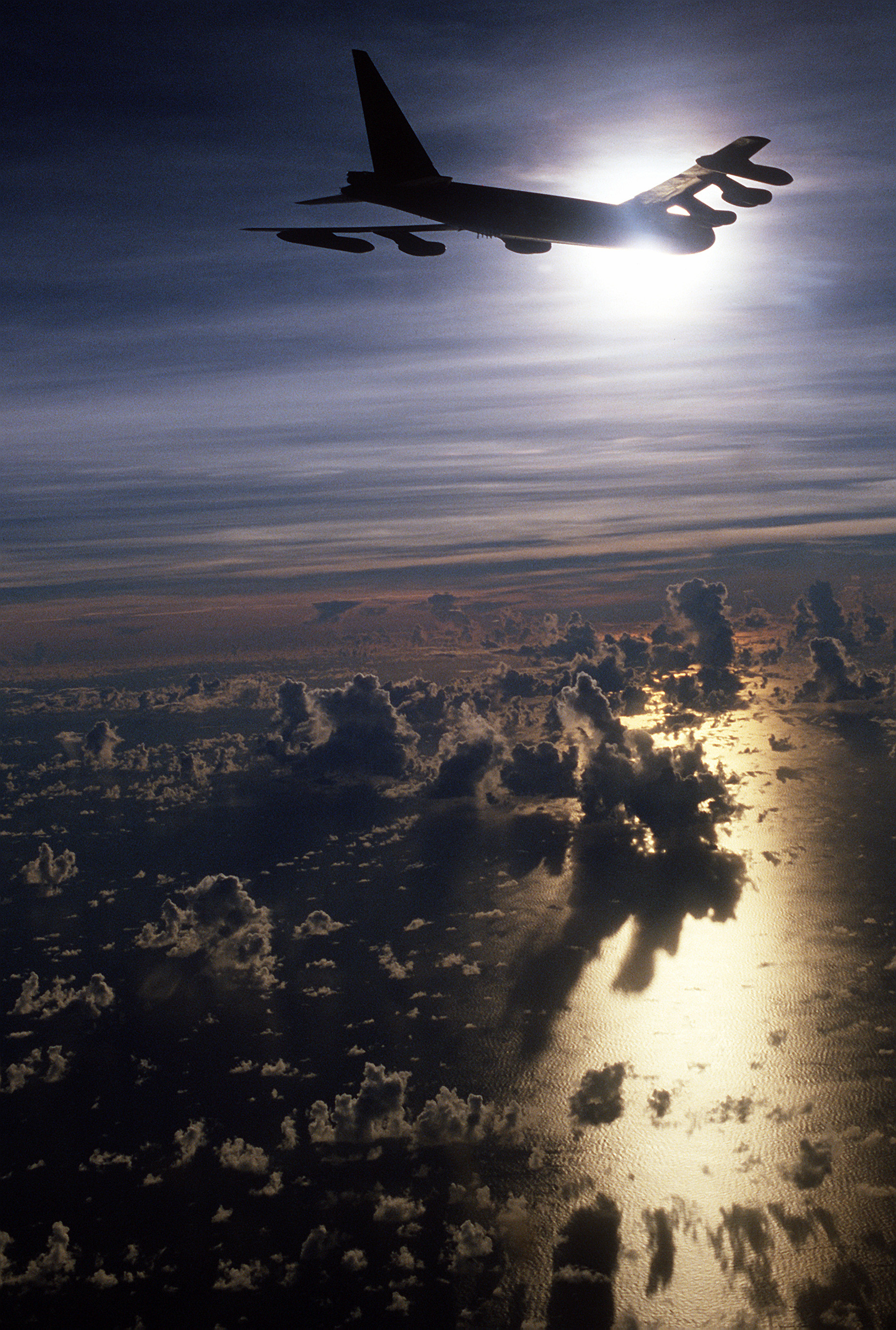
Large Medium Other Original
34. A U.S. Air Force B-52 Stratofotress Heavy Bomber Flies Over a Cloud-Covered Ocean, May 31, 1986 |
| |

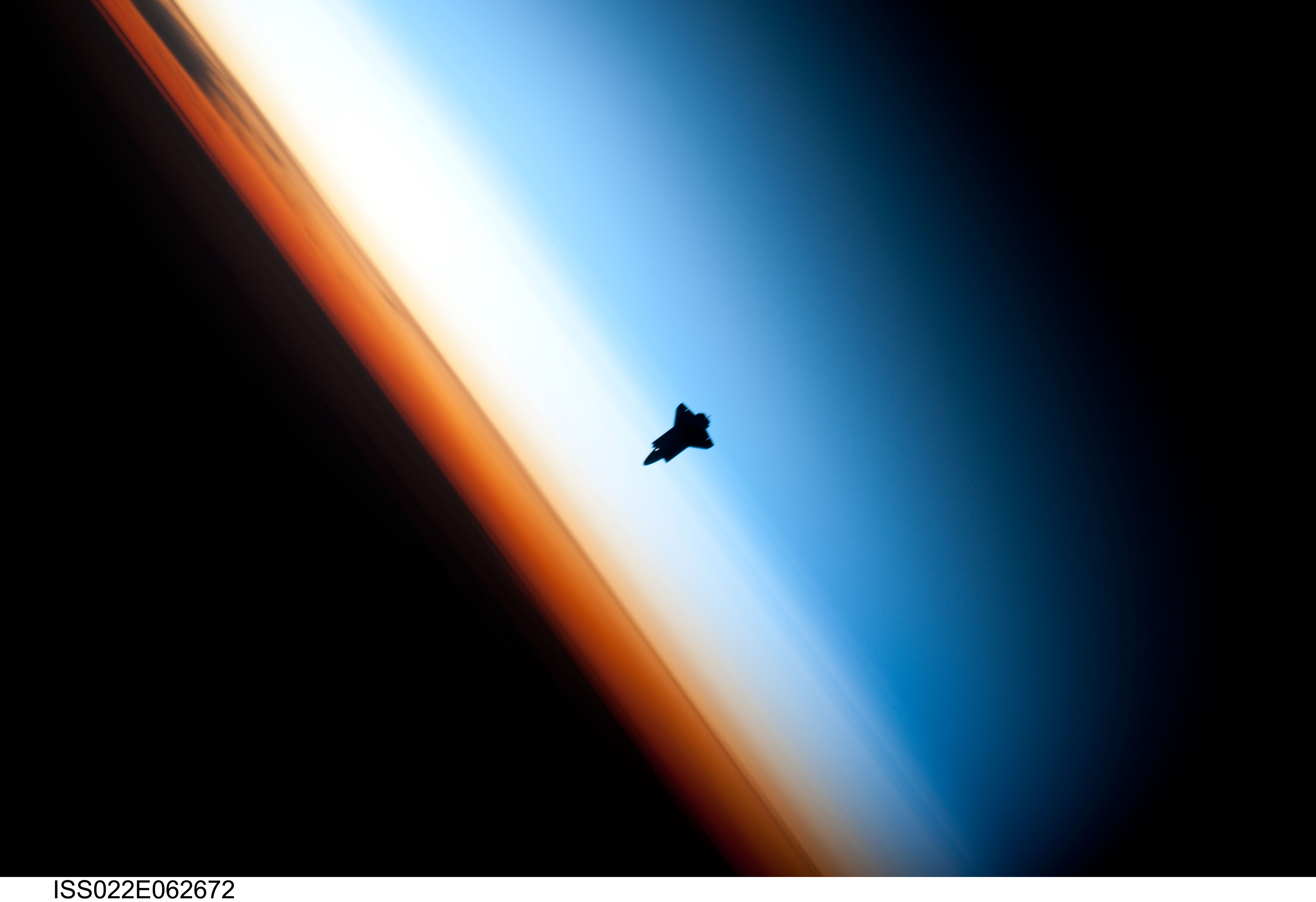
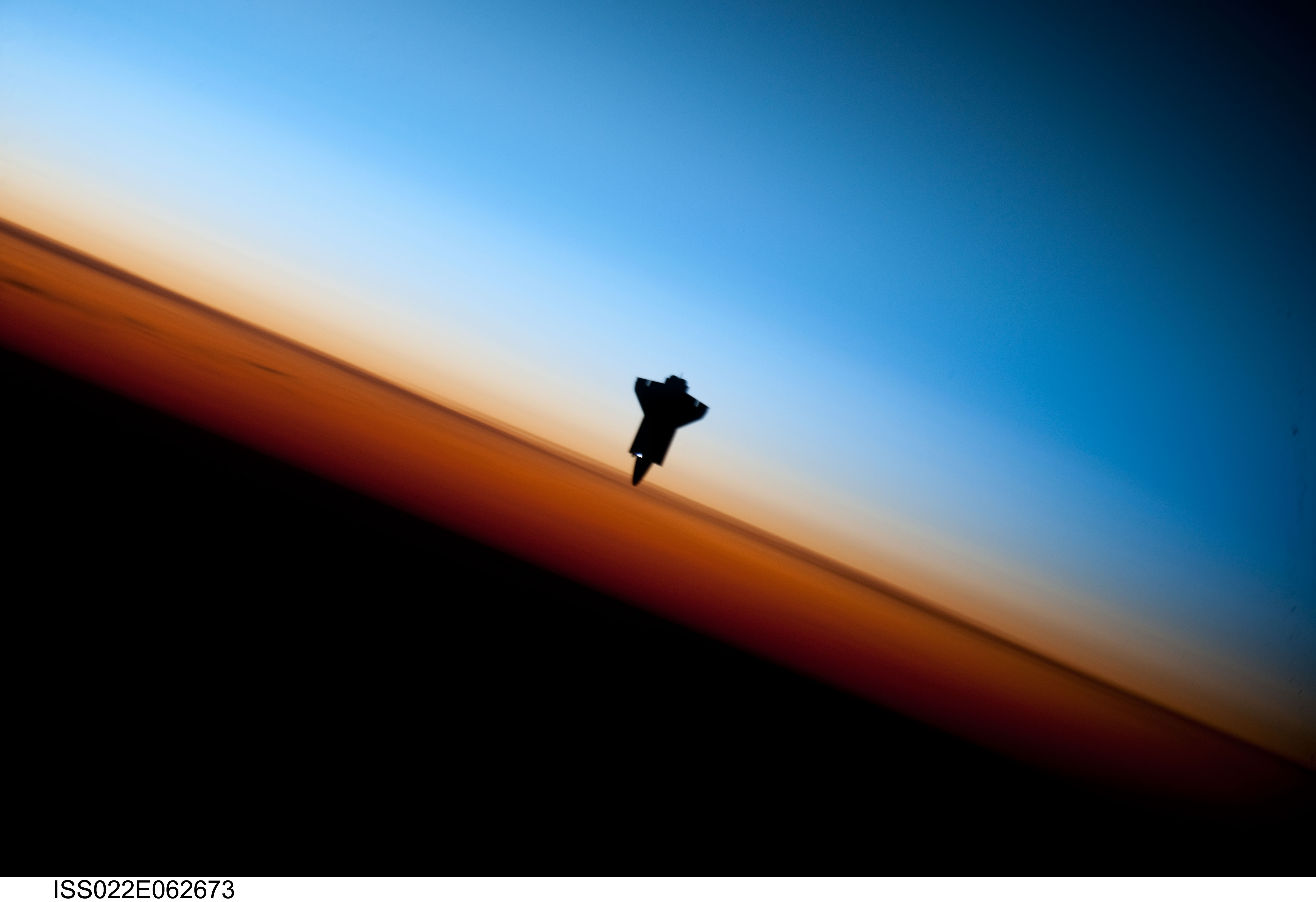
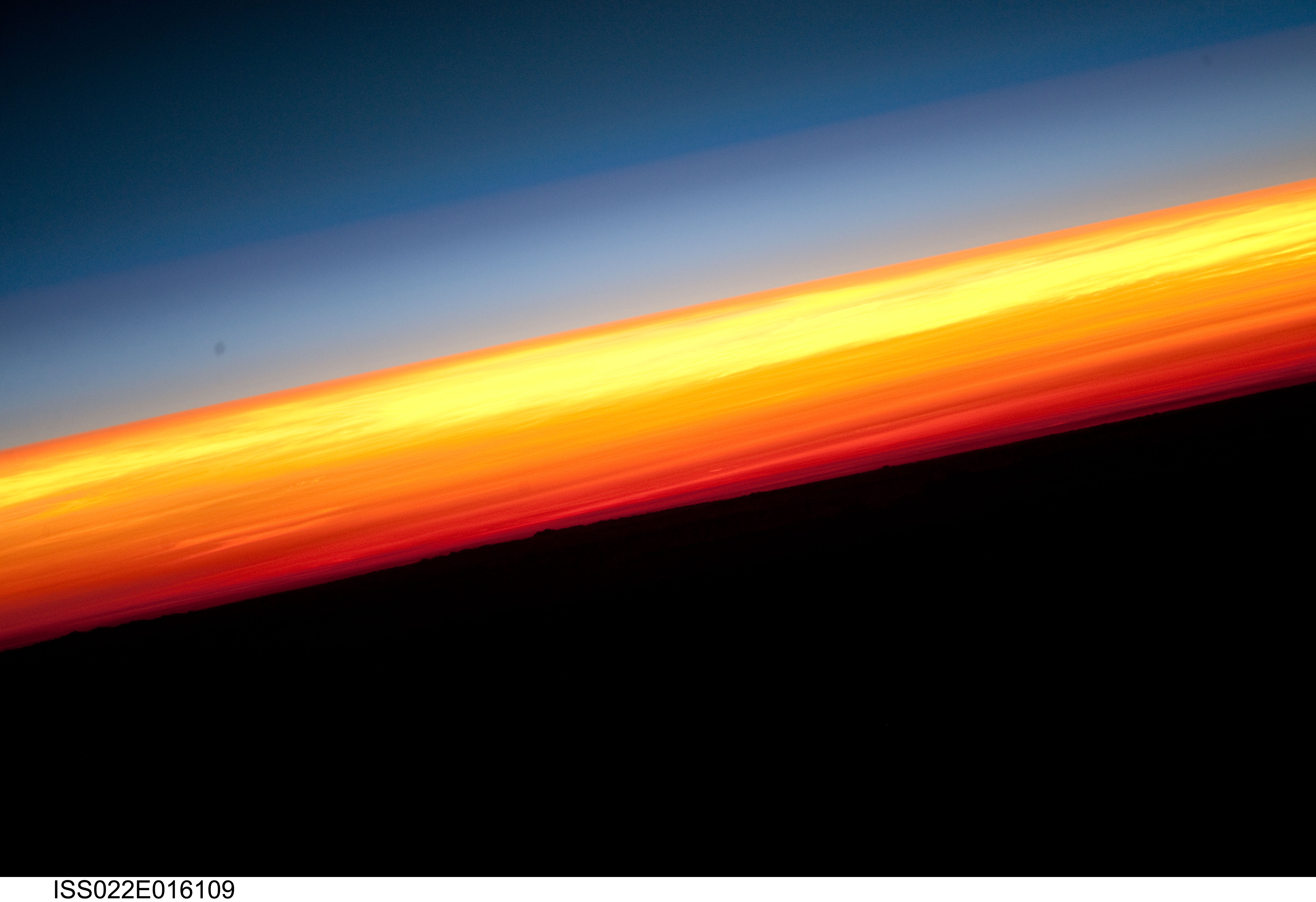
Huge Large Medium Other Original
35. Orbital Sunset: Beautiful View of Earth's Colorful Horizon and the Silhouette of Space Shuttle Endeavour (STS-130), February 9, 2010
As Seen From the International Space Station (Expedition 22) While Orbiting Above the South Pacific Ocean Off the Coast of Southern Chile
Latitude (LAT): -46.9 · Longitude (LON): -80.5 · Altitude (ALT): 183 Nautical Miles |
| |
|
International Space Station video of Space Shuttle Endeavour (STS-130) and the colorful sunset of 9 February 2010, two hours before docking
http://www.YouTube.com/watch?v=HHgtED2PfAc |
| |
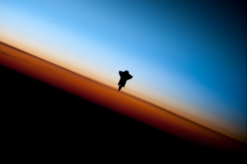
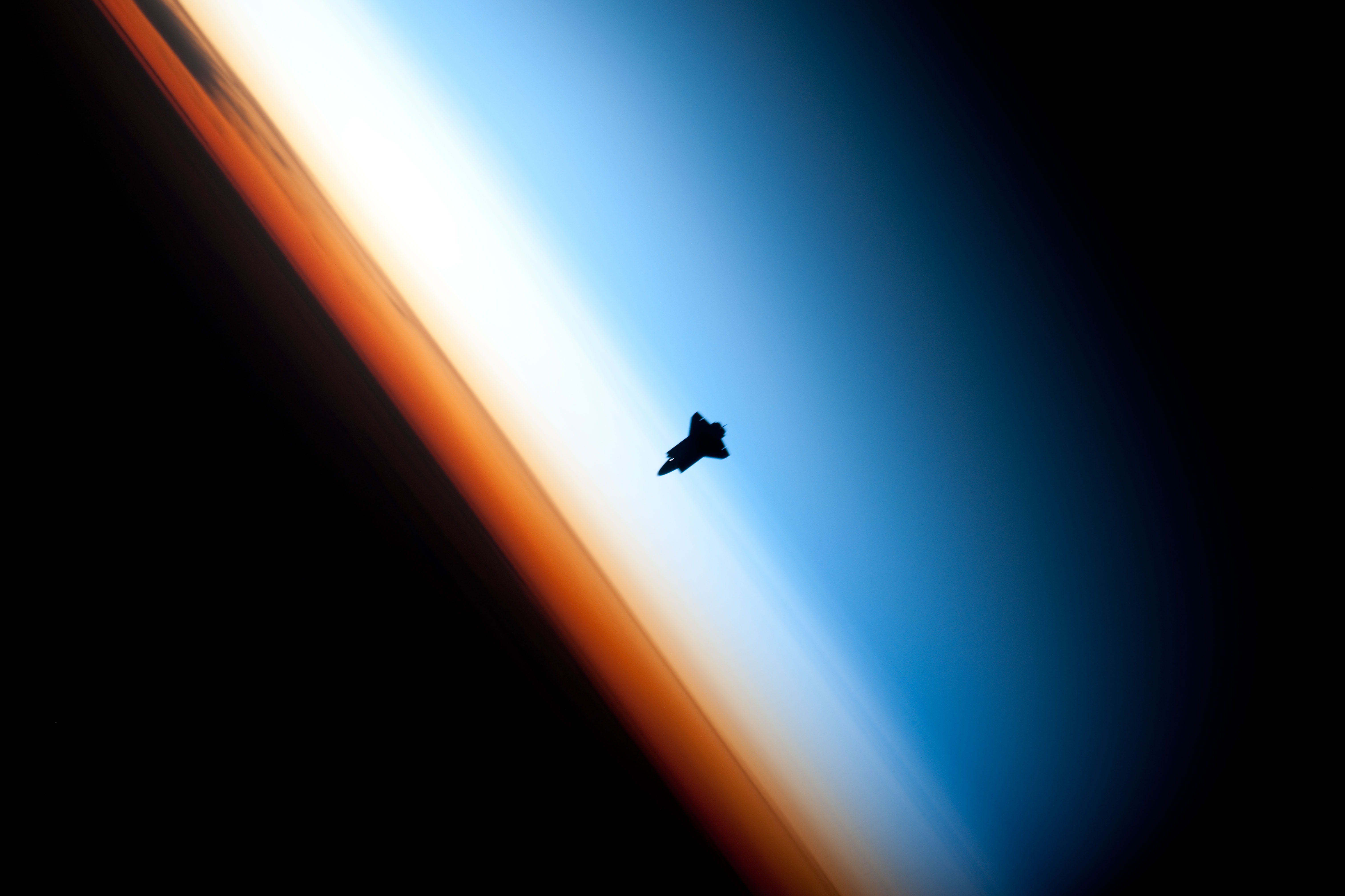
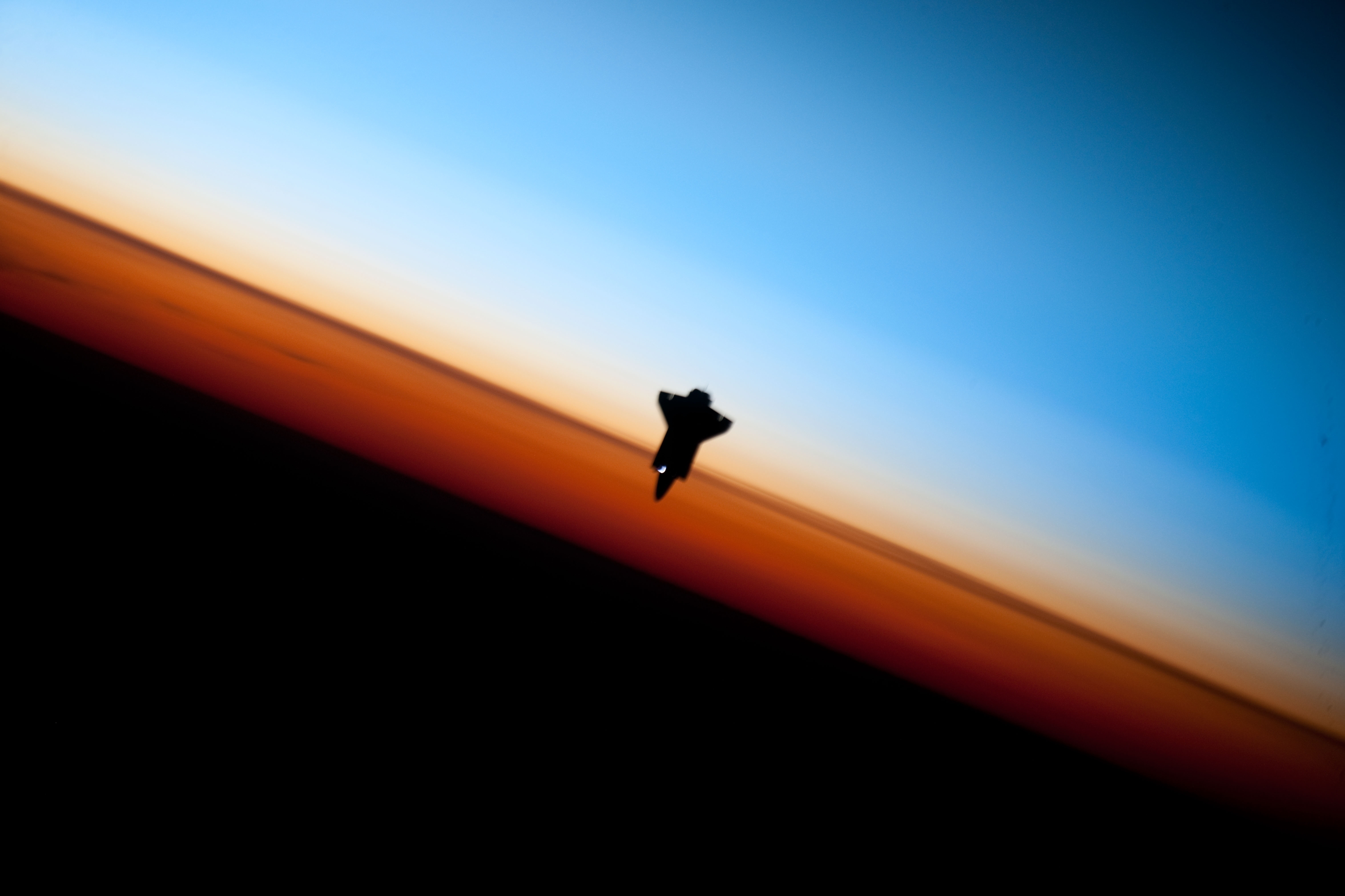
Huge Large Medium Other Original
36. Orbital Sunset: Silhouette of Space Shuttle Endeavour (STS-130) and Earth's Colorful Horizon, February 9, 2010
As Seen From the International Space Station (Expedition 22) While Above the South Pacific Ocean Off the Coast of Southern Chile
Latitude (LAT): -46.9 · Longitude (LON): -80.5 · Altitude (ALT): 183 Nautical Miles |
| |
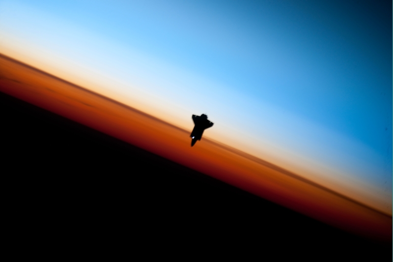
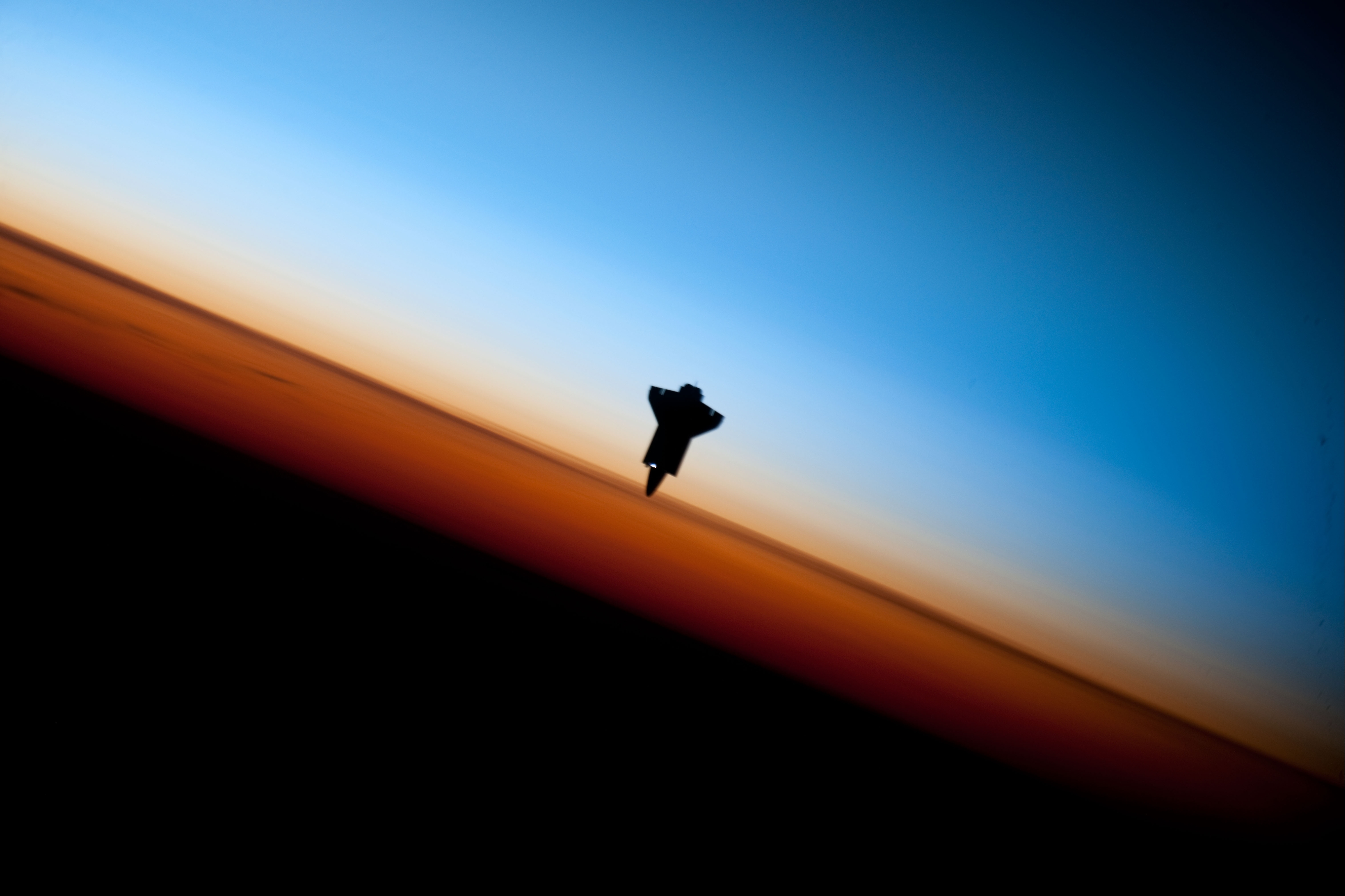
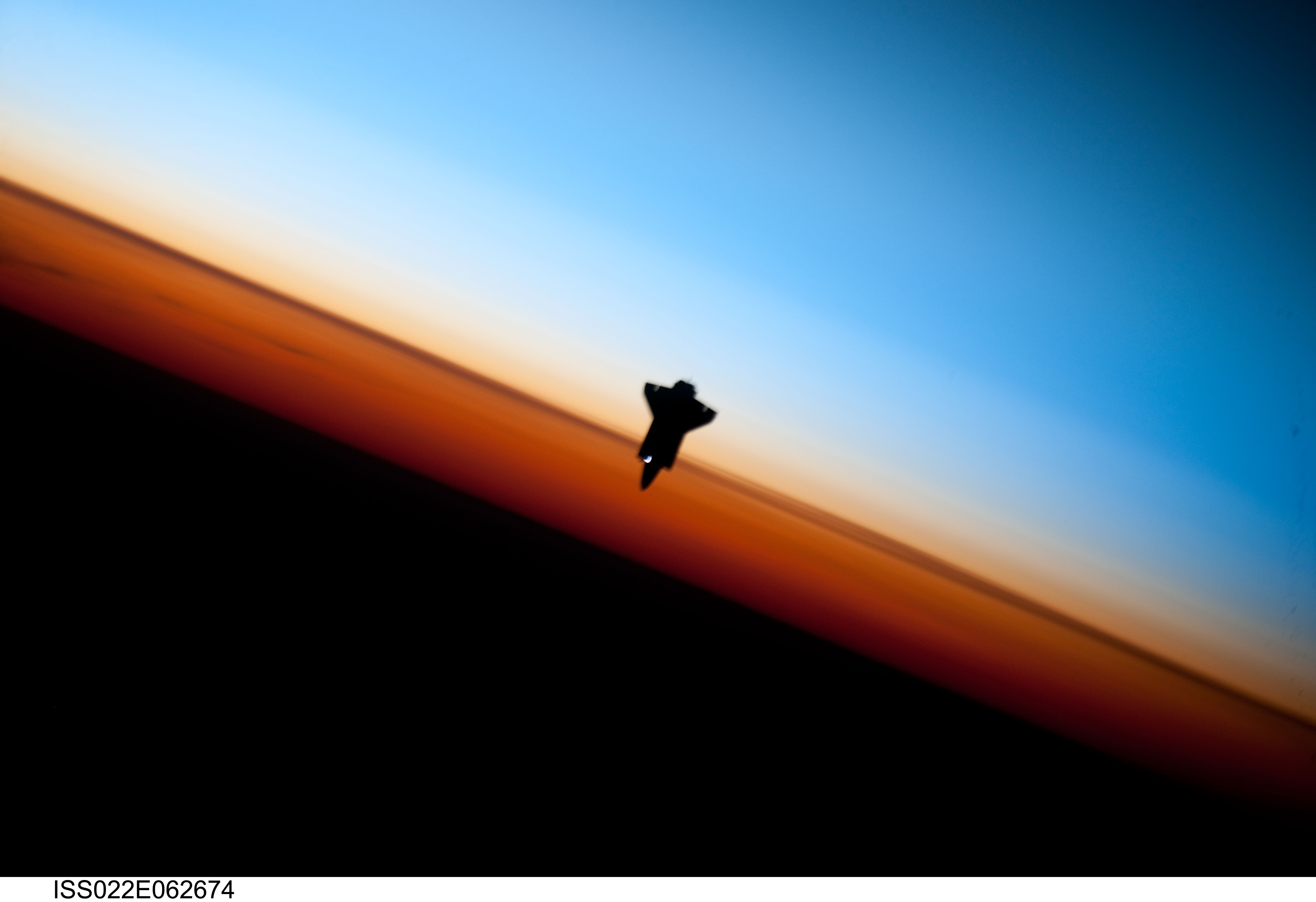
Huge Large Medium Other Original
37. Orbital Sunset: Striking View of Earth's Colorful Horizon and the Silhouette of Space Shuttle Endeavour (STS-130), February 9, 2010
As Seen From the International Space Station (Expedition 22) While Orbiting Above the South Pacific Ocean Off the Coast of Southern Chile
Latitude (LAT): -46.9 · Longitude (LON): -80.5 · Altitude (ALT): 183 Nautical Miles |
| |
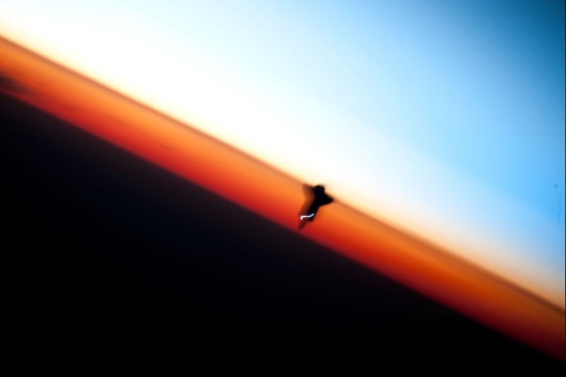
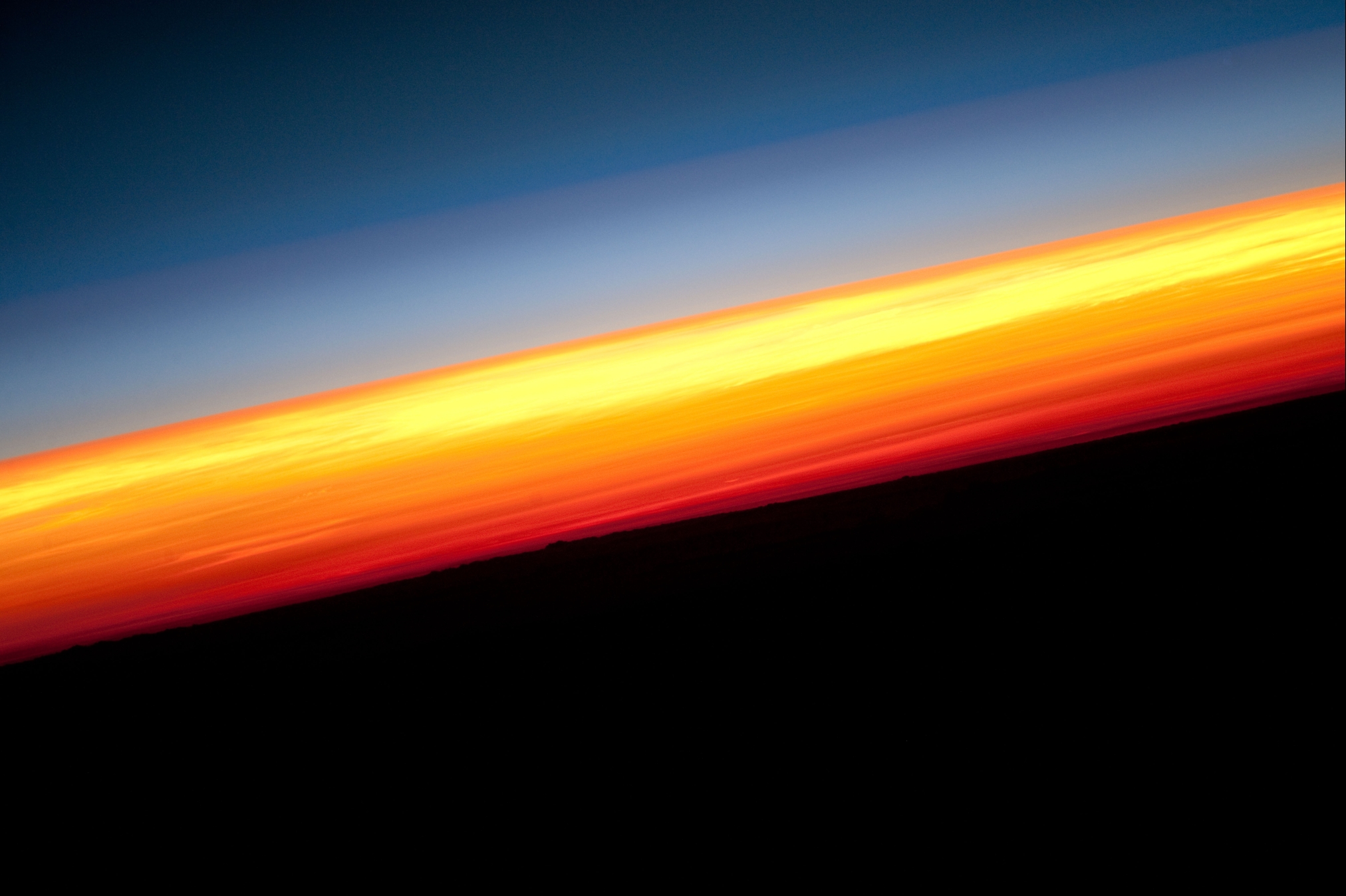
Huge Large Medium Other Original
38. Orbital Sunset: Earth's Colorful Horizon and the Silhouette of Space Shuttle Endeavour (STS-130), February 9, 2010
As Seen From the International Space Station (Expedition 22) While Orbiting Above the South Pacific Ocean Off the Coast of Southern Chile
Latitude (LAT): -46.9 · Longitude (LON): -80.5 · Altitude (ALT): 183 Nautical Miles |
| |
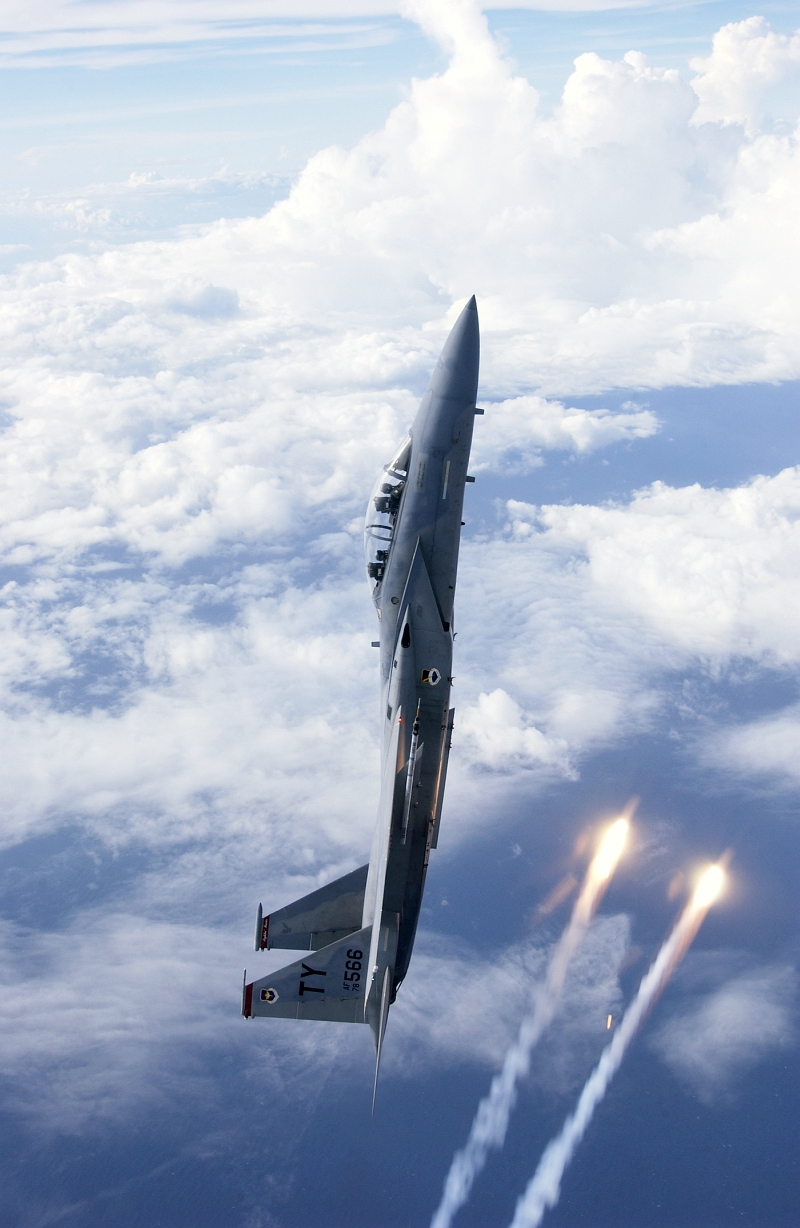
Large Medium Original
39. A U.S. Air Force F-15D Eagle Fighter Jet In A Vertical Climb Above the Clouds As Flares Streak By |
| |

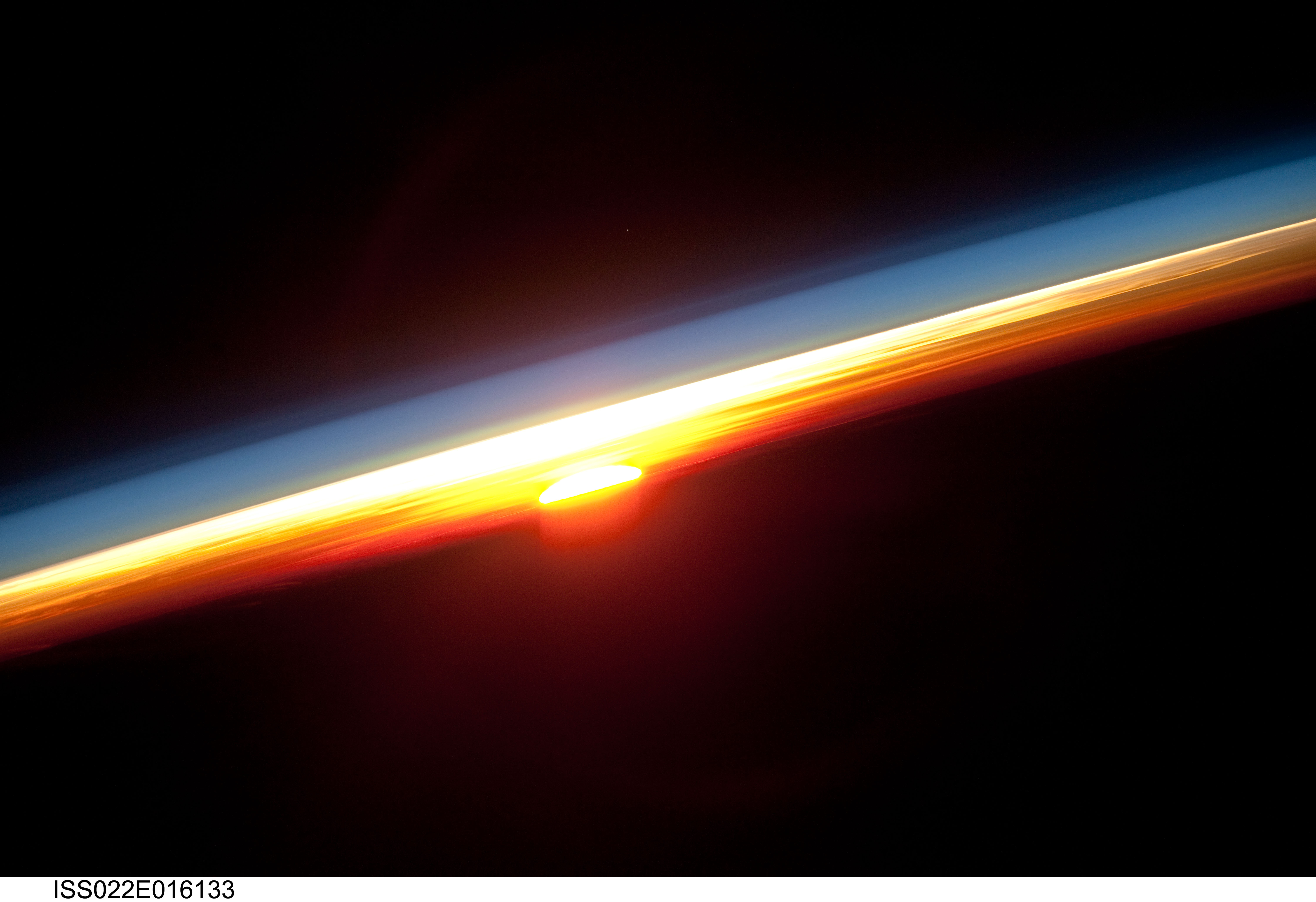
Huge Large Medium Other
40. Earth's Colorful Horizon, January 3, 2010 at 12:27:52 GMT
As Seen From the International Space Station (Expedition 22) While Orbiting Over the North Pacific Ocean
Latitude (LAT): 4.9 · Longitude (LON): -117.0 · Altitude (ALT): 180 Nautical Miles · Sun Azimuth (AZI): 113° · Sun Elevation Angle (ELEV): -21° |
| |
Huge Large Medium Other
41. Earth's Blue Atmospheric Limb, Earth's Sun, and Earth's Colorful Horizon, January 3, 2010 at 12:28:57 GMT
As Seen From the International Space Station (Expedition 22) While Orbiting Over the North Pacific Ocean
Latitude (LAT): 1.5 · Longitude (LON): -114.6 · Altitude (ALT): 181 Nautical Miles · Sun Azimuth (AZI): 113° · Sun Elevation Angle (ELEV): -18° |
| |
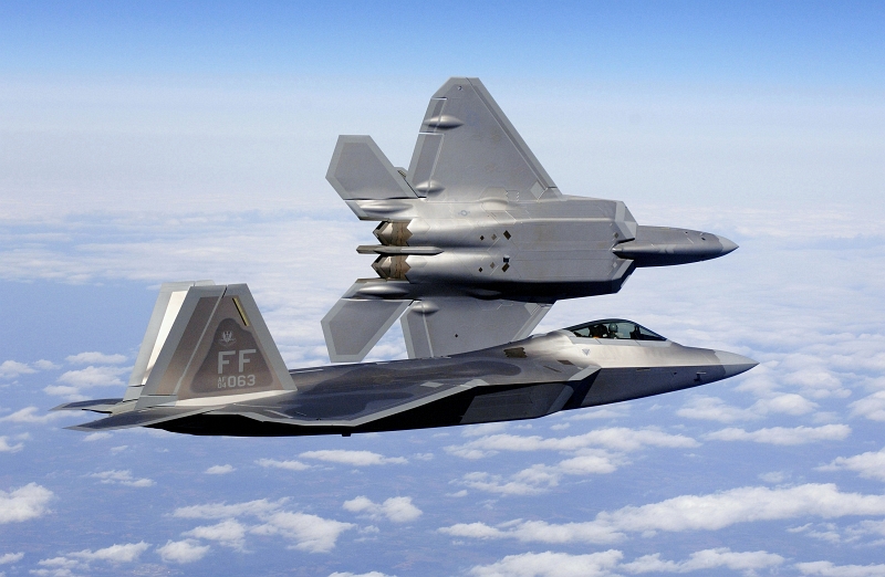
Large Medium Other Original
42. New U.S. Air Force F-22A Raptor Stealth Fighter Jets Fly Over the Continental United States of America, March 3, 2006 |
| |

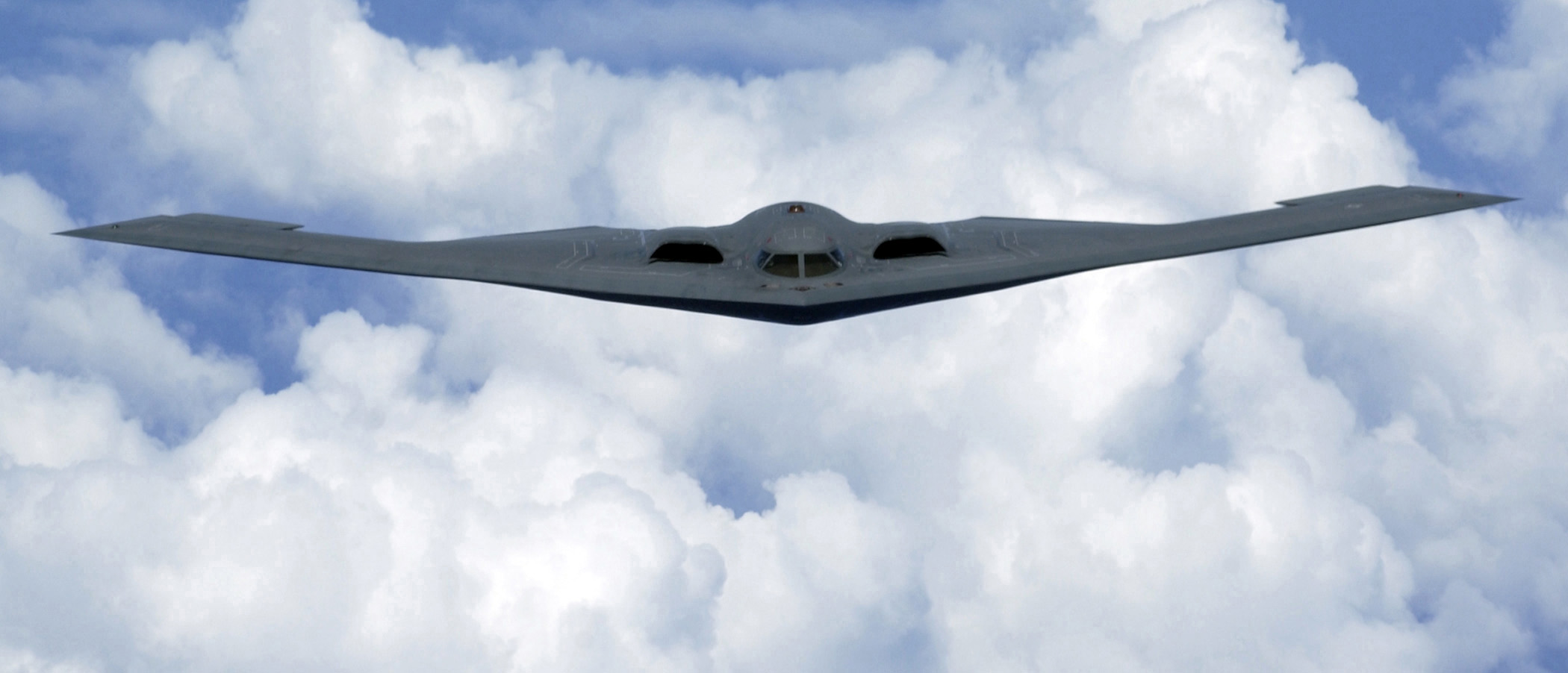
Large Medium Other
43. U.S. Air Force B-2 Spirit Stealth Bomber Flying Over the Pacfic Ocean, May 2, 2005 |
| |
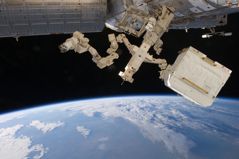
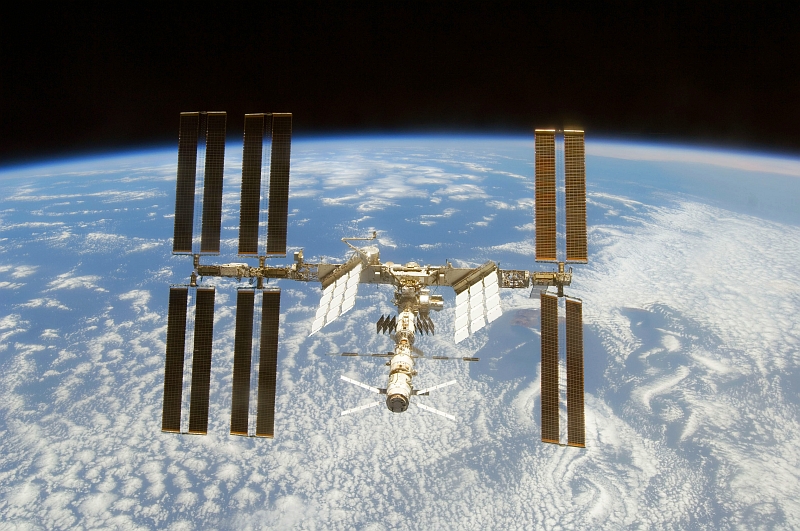
Huge Large Medium Other Original
44. Dextre -- Backdropped By the Blackness of Space and Earth's Blue Horizon -- Orbits Over Blue-and-White Earth, April 18, 2011
As Seen From the International Space Station (Expedition 27) |
| |
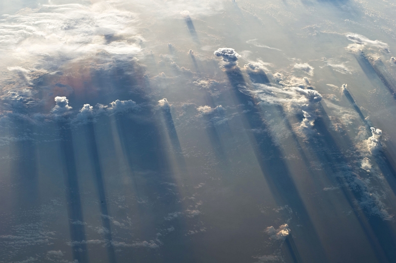
Huge Large Medium Other Original
45. Clouds and Their Long Shadows, May 19, 2011 at 12:20:26 GMT
As Seen From the International Space Station (Expedition 27) While Over the North Pacific Ocean, West of Mexico
Latitude (LAT): 14.3 · Longitude (LON): -102.4 · Altitude (ALT): 185 Nautical Miles · Sun Azimuth (AZI): 69° · Sun Elevation Angle (ELEV): -1° |
| |
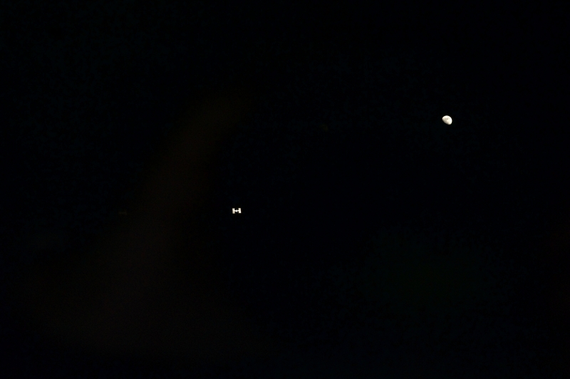
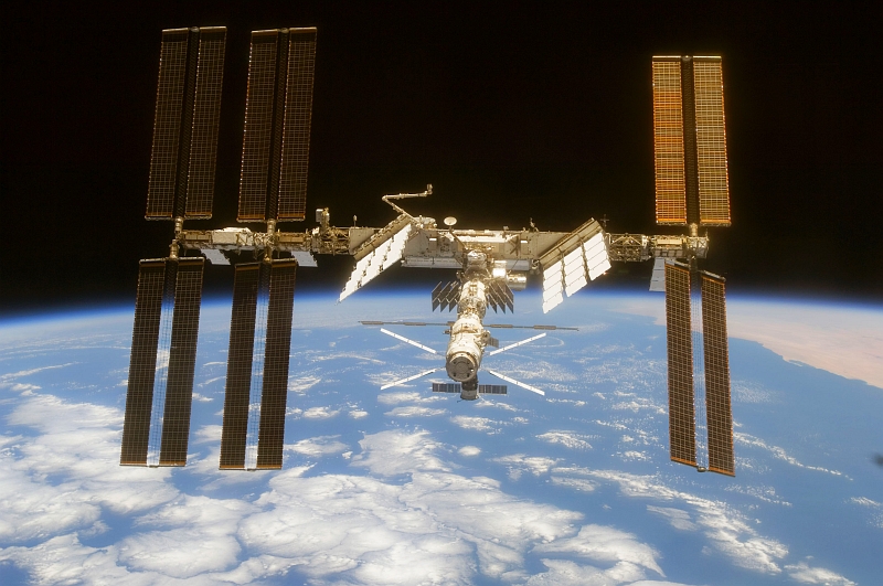
Huge Large Medium Other Original
46. The International Space Station and Earth's Moon Surrounded By the Blackness of Space, July 10, 2011
As Seen From Space Shuttle Atlantis (STS-135) |
| |
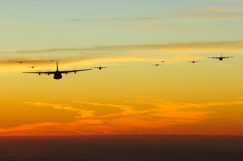
Huge Large Medium Other
47. Exercise Bayonet Resolve: At Dawn, U.S. Air Force C-130J Super Hercules Aircraft From the 37th Airlift Squadron at
Ramstein Air Base, Germany, Fly In A 10-Ship Formation Over Southern Germany, October 5, 2011
Bundesrepublik Deutschland – Federal Republic of Germany |
| |

Huge Large Medium Other Original
48. Cloud Patterns, July 26, 2013 at 20:40:51 GMT
As Seen From the International Space Station (Expedition 36) While Orbiting Over the South Pacific Ocean
Latitude (LAT): -44.3 · Longitude (LON): -113.1 · Altitude (ALT): 226 Nautical Miles · Sun Azimuth (AZI): 344° · Sun Elevation Angle (ELEV): 25° |
| |
Huge, Large, Medium, Other, Original
48a. July 26, 2013 at 20:40:37 GMT
Latitude: -43.8 · Longitude: -114.2
ISS036-E-25841 |

Huge, Large, Medium, Other, Original
48b. July 26, 2013 at 20:40:40 GMT
Latitude: -43.9 · Longitude: -113.9
ISS036-E-25842 |
Huge, Large, Medium, Other, Original
48c. July 26, 2013 at 20:40:51 GMT
Latitude: -44.3 · Longitude: -113.1
ISS036-E-25843 |
Huge, Large, Medium, Other, Original
48d. July 26, 2013 at 20:41:22 GMT
Latitude: -45.2 · Longitude:-110.8
ISS036-E-25844 |
| |
|
Actinoform Clouds » NASA Earth Observatory » Image of the Day » July 19, 2012 » Evolving Views of Clouds »
https://earthobservatory.nasa.gov/IOTD/view.php?id=78562
https://web.archive.org/web/20171212225120/earthobservatory.nasa.gov/IOTD/view.php?id=78562
|
| |
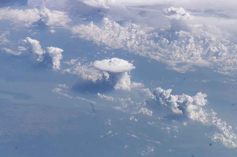
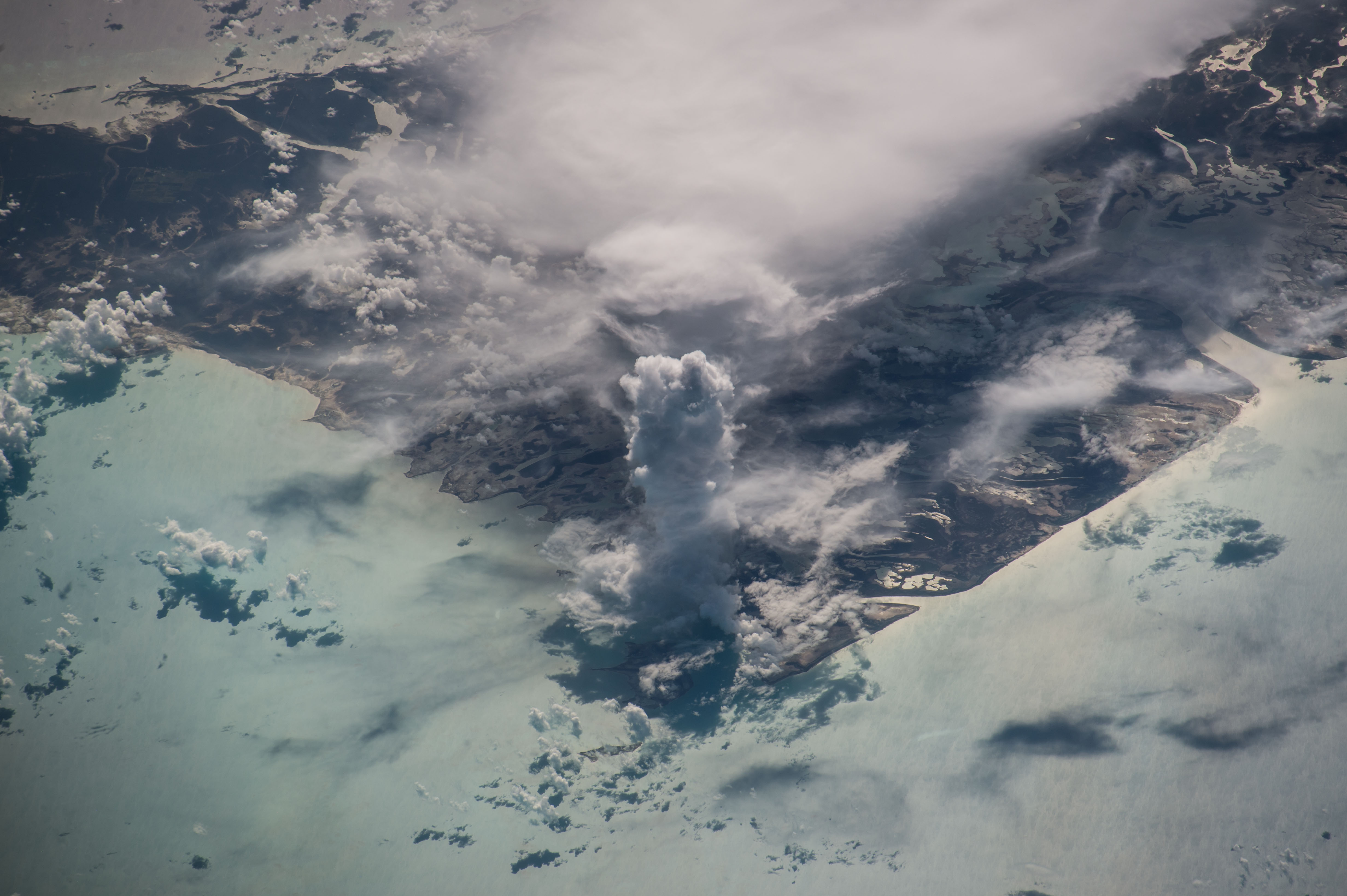
Huge Large Medium Other Original
49. A Huge, Vertical, Pillar of A Cloud: Cumulus Castellanus Over Andros Island, 19 July 2016 at 13:30:14 GMT
Commonwealth of The Bahamas, United Kingdom of Great Britain and Northern Ireland
As Seen From the International Space Station (Expedition 48) While Orbiting Over the Gulf of Mexico
ISS Nadir Latitude: 23.4 · ISS Nadir Longitude: -83.7 · Altitude: 216 Nautical Miles · Sun Azimuth: 79° · Sun Elevation Angle: 32°
Photo Center Point Latitude: 24.7 · Photo Center Point Longitude: -78.3 · Nadir to Photo Center: East |
Photo Credits:
1. First Row (Full size Original–Local copy, Large or Medium): Senior Master Sgt. Ray Lloyd, United States Air Force (USAF, http://www.af.mil); DefenseLINK Multimedia Gallery - Images (http://www.DefenseLink.mil/multimedia/, 061004-F-0996L-041), United States Department of Defense (DoD, http://www.DefenseLink.mil or http://www.dod.gov), Government of the United States of America (USA).
2. Second Row (Full size Original–Local copy, Large, or Medium): ISS015-E-23716, International Space Station (Expedition 15); Image Science and Analysis Laboratory, NASA-Johnson Space Center. "Astronaut Photography of Earth - Display Record." <http://eol.jsc.nasa.gov/scripts/sseop/photo.pl?mission=ISS015&roll=E&frame=23716>; National Aeronautics and Space Administration (NASA, http://www.nasa.gov), Government of the United States of America (USA). See also ISS015-E-23712 <http://eol.jsc.nasa.gov/scripts/sseop/photo.pl?mission=ISS015&roll=E&frame=23712>, ISS015-E-23713 <http://eol.jsc.nasa.gov/scripts/sseop/photo.pl?mission=ISS015&roll=E&frame=23713>, ISS015-E-23714 <http://eol.jsc.nasa.gov/scripts/sseop/photo.pl?mission=ISS015&roll=E&frame=23714>, ISS015-E-23715 <http://eol.jsc.nasa.gov/scripts/sseop/photo.pl?mission=ISS015&roll=E&frame=23715>.
3. Third Row (Full size Original–Local copy, Large, or Medium): STS-115 Shuttle Mission Imagery (http://spaceflight.nasa.gov/gallery/images/shuttle/sts-115/ndxpage1.html), S115-E-06684 (http://spaceflight.nasa.gov/gallery/images/shuttle/sts-115/html/s115e06684.html), NASA Human Space Flight (http://spaceflight.nasa.gov), National Aeronautics and Space Administration (NASA, http://www.nasa.gov), Government of the United States of America.
4. Fourth Row (Full size Original–Local copy, Large, or Medium): Mass Communication Specialist 2nd Class Kristopher Wilson, Navy NewsStand – Eye on the Fleet Photo Gallery (http://www.news.navy.mil/view_photos.asp, 070602-N-5345W-358), United States Navy (USN, http://www.navy.mil), United States Department of Defense (DoD, http://www.DefenseLink.mil or http://www.dod.gov), Government of the United States of America (USA).
5. Fifth Row (Full size Original–Local copy, Large, or Medium): NASA Astronaut Dr. Edward Tsang Lu, Ph.D. aboard the International Space Station (Expedition 7); ISS007-E-14887, Hurricane Isabel's Eye, Atlantic Ocean; Image Science and Analysis Laboratory, NASA-Johnson Space Center. "Astronaut Photography of Earth - Display Record." <http://eol.jsc.nasa.gov/scripts/sseop/photo.pl?mission=ISS007&roll=E&frame=14887>; National Aeronautics and Space Administration (NASA, http://www.nasa.gov), Government of the United States of America (USA).
6. Sixth Row (Full size Original–Local copy, Large, or Medium): NASA Astronaut Dr. Edward Tsang Lu, Ph.D. aboard the International Space Station (Expedition 7); ISS007-E-14745, Detailed view of Hurricane Isabel's eye, Eyewall structure, Atlantic Ocean; Image Science and Analysis Laboratory, NASA-Johnson Space Center. "Astronaut Photography of Earth - Display Record." <http://eol.jsc.nasa.gov/scripts/sseop/photo.pl?mission=ISS007&roll=E&frame=14745>; National Aeronautics and Space Administration (NASA, http://www.nasa.gov), Government of the United States of America (USA).
7. Seventh Row (Full size Original–Local copy, Large, or Medium): STS-118 Shuttle Mission Imagery (http://spaceflight.nasa.gov/gallery/images/shuttle/sts-118/ndxpage1.html), ISS015-E-22561 (http://spaceflight.nasa.gov/gallery/images/shuttle/sts-118/html/iss015e22561.html), NASA Human Space Flight (http://spaceflight.nasa.gov), National Aeronautics and Space Administration (NASA, http://www.nasa.gov), Government of the United States of America.
8. Eighth Row (Full size Original–Local copy, Large, or Medium): NASA; ISS015-E-25049, Hurricane Felix, Eye, Bands of wind, Rainbands (Bands of rain), Caribbean Sea, International Space Station (Expedition 15); Image Science and Analysis Laboratory, NASA-Johnson Space Center. "Astronaut Photography of Earth - Display Record." <http://eol.jsc.nasa.gov/scripts/sseop/photo.pl?mission=ISS015&roll=E&frame=25049>; National Aeronautics and Space Administration (NASA, http://www.nasa.gov), Government of the United States of America (USA).
9. Ninth Row (Full size Original–Local copy, Large, or Medium): NASA; ISS015-E-25058, Hurricane Felix, Eye, Bands of wind, Bands of rain (Rainbands), Caribbean Sea, International Space Station (Expedition 15); Image Science and Analysis Laboratory, NASA-Johnson Space Center. "Astronaut Photography of Earth - Display Record." <http://eol.jsc.nasa.gov/scripts/sseop/photo.pl?mission=ISS015&roll=E&frame=25058>; National Aeronautics and Space Administration (NASA, http://www.nasa.gov), Government of the United States of America (USA).
10. Tenth Row (Full size Original–Local copy, Large, Medium, or Other): NASA Apollo 17 Astronauts; AS17-148-22727, Planet Earth -- Africa (African continent), Antarctica, Arabian Peninsula, Asian mainland, Republic of Madagascar, Oceans; Image Science and Analysis Laboratory, NASA-Johnson Space Center. "Astronaut Photography of Earth - Display Record." <http://eol.jsc.nasa.gov/scripts/sseop/photo.pl?mission=AS17&roll=148&frame=22727>; National Aeronautics and Space Administration (NASA, http://www.nasa.gov), Government of the United States of America (USA).
11. Eleventh Row (Full size Original–Local copy, Large, or Medium): NASA; ISS015-E-27038, Clouds over the Pacific Ocean, Off the coast of Chile, International Space Station (Expedition 15); Image Science and Analysis Laboratory, NASA-Johnson Space Center. "Astronaut Photography of Earth - Display Record." <http://eol.jsc.nasa.gov/scripts/sseop/photo.pl?mission=ISS015&roll=E&frame=27038>; National Aeronautics and Space Administration (NASA, http://www.nasa.gov), Government of the United States of America (USA).
12. Twelfth Row (Full size Original–Local copy, Large, or Medium): NASA; STS107-E-5059, von Karman vortices, von Karman vortex street, Space Shuttle Columbia (STS-107 Mission); Image Science and Analysis Laboratory, NASA-Johnson Space Center. "Astronaut Photography of Earth - Display Record." <http://eol.jsc.nasa.gov/scripts/sseop/photo.pl?mission=STS107&roll=E&frame=5059>; National Aeronautics and Space Administration (NASA, http://www.nasa.gov), Government of the United States of America (USA).
13. Thirteenth Row (Full size Original–Local copy, Large, or Medium): NASA; ISS007-E-6047, 100% cloud cover, von Karman vortexes, von Karman vortex street, International Space Station (Expedition 7); Image Science and Analysis Laboratory, NASA-Johnson Space Center. "Astronaut Photography of Earth - Display Record." <http://eol.jsc.nasa.gov/scripts/sseop/photo.pl?mission=ISS007&roll=E&frame=6047>; National Aeronautics and Space Administration (NASA, http://www.nasa.gov), Government of the United States of America (USA).
14. Fourteenth Row (Full size Original, Large, or Medium): The ASTER (Advanced Spaceborne Thermal Emission and Reflection Radiometer) Project (http://asterweb.jpl.nasa.gov) and NASA/GSFC/METI/ERSDAC/JAROS, and U.S./Japan ASTER Science Team; EROS (Earth Resources Observation and Science, http://eros.usgs.gov) Image Gallery Collections (http://eros.usgs.gov/imagegallery) - Earth As Art 2 Image Collection (http://eros.usgs.gov/imagegallery/collection.php?col=Earth+As+Art+2) - Alluvial Fan, United States Geological Survey (USGS, http://www.usgs.gov), United States Department of the Interior (http://www.doi.gov) and National Aeronautics and Space Administration (NASA, http://www.nasa.gov), Government of the United States of America (USA).
15. Fifteenth Row (Full size Original–Local copy, Large, or Medium): NASA; ISS015-E-27661, Wake pattern, Stratus clouds, International Space Station (Expedition 15); Image Science and Analysis Laboratory, NASA-Johnson Space Center. "Astronaut Photography of Earth - Display Record." <http://eol.jsc.nasa.gov/scripts/sseop/photo.pl?mission=ISS015&roll=E&frame=27661>; National Aeronautics and Space Administration (NASA, http://www.nasa.gov), Government of the United States of America (USA).
16. Sixteenth Row (Full size Original–Local copy, Large, or Medium): NASA; ISS015-E-33552, Clouds, International Space Station (Expedition 15); Image Science and Analysis Laboratory, NASA-Johnson Space Center. "Astronaut Photography of Earth - Display Record." <http://eol.jsc.nasa.gov/scripts/sseop/photo.pl?mission=ISS015&roll=E&frame=33552>; National Aeronautics and Space Administration (NASA, http://www.nasa.gov), Government of the United States of America (USA).
17. Seventeenth Row (Full size Original–Local copy, Large, or Medium): NASA; ISS015-E-34872, Earth's limb, Clouds, North Africa, Mediterranean Sea, Nile River, Nile River Delta, Gulf of Suez, Sinai Peninsula, International Space Station (Expedition 15); Image Science and Analysis Laboratory, NASA-Johnson Space Center. "Astronaut Photography of Earth - Display Record." <http://eol.jsc.nasa.gov/scripts/sseop/photo.pl?mission=ISS015&roll=E&frame=34872>; National Aeronautics and Space Administration (NASA, http://www.nasa.gov), Government of the United States of America (USA).
18. Eighteenth Row (Full size Original–Local copy, Large, or Medium): NASA; ISS015-E-14611, Contrails, Cloud layer, Celebes Sea, Western Pacific Ocean, International Space Station (Expedition 15); Image Science and Analysis Laboratory, NASA-Johnson Space Center. "Astronaut Photography of Earth - Display Record." <http://eol.jsc.nasa.gov/scripts/sseop/photo.pl?mission=ISS015&roll=E&frame=14611>; National Aeronautics and Space Administration (NASA, http://www.nasa.gov), Government of the United States of America (USA).
19. Nineteenth Row (Full size Original–Local copy, Large, or Medium): NASA; ISS015-E-20487, Moon (Luna), Earth's Blue Atmospheric Limb, Clouds, Pacific Ocean, International Space Station (Expedition 15); Image Science and Analysis Laboratory, NASA-Johnson Space Center. "Astronaut Photography of Earth - Display Record." <http://eol.jsc.nasa.gov/scripts/sseop/photo.pl?mission=ISS015&roll=E&frame=20487>; National Aeronautics and Space Administration (NASA, http://www.nasa.gov), Government of the United States of America (USA).
20. Twentieth Row (Full size Original–Local copy, Large, or Medium): STS-120 Shuttle Mission Imagery (http://spaceflight.nasa.gov/gallery/images/shuttle/sts-120/ndxpage1.html), S120-E-008224 (http://spaceflight.nasa.gov/gallery/images/shuttle/sts-120/html/s120e008224.html), NASA Human Space Flight (http://spaceflight.nasa.gov), National Aeronautics and Space Administration (NASA, http://www.nasa.gov), Government of the United States of America.
21. Twentieth-First Row (Full size Original–Local copy, Large, or Medium): National Aeronautics and Space Administration (NASA, http://www.nasa.gov, STS41B-35-1659, http://eol.jsc.nasa.gov/scripts/sseop/photo.pl?mission=STS41B&roll=35&frame=1659), Space Shuttle Challenger (STS-41-B); Defense Visual Information Center (DVIC, http://www.DoDMedia.osd.mil, DF-SC-84-10569) and United States Air Force (USAF, http://www.af.mil), United States Department of Defense (DoD, http://www.DefenseLink.mil or http://www.dod.gov), Government of the United States of America (USA).
22. Twenty-Second Row (Full size Original–Local copy, Large, or Medium): NASA; ISS015-E-9310, Atlantic Ocean, Newfoundland and Labrador, Canada, International Space Station (Expedition 15); Image Science and Analysis Laboratory, NASA-Johnson Space Center. "Astronaut Photography of Earth - Display Record." <http://eol.jsc.nasa.gov/scripts/sseop/photo.pl?mission=ISS015&roll=E&frame=9310>; National Aeronautics and Space Administration (NASA, http://www.nasa.gov), Government of the United States of America (USA).
23. Twenty-Third Row (Full size Original, Large, or Medium): NASA; Earth's atmospheric limb, Space Shuttle Endeavour (STS-66) Remote Manipulator System (RMS) Canada Arm (Robot Arm), Sunburst over Earth, GRIN (http://grin.hq.nasa.gov) Database Number: GPN-2000-001097, National Aeronautics and Space Administration (NASA, http://www.nasa.gov), Government of the United States of America.
24. Twenty-Fourth Row (Full size Original–Local copy, Large, or Medium): NASA; ISS007-E-16807, Clouds, Oahu, Hawaii, Honolulu International Airport, Ke'ehi Lagoon, Sand Island, Pacific Ocean, International Space Station (Expedition 7); Image Science and Analysis Laboratory, NASA-Johnson Space Center. "Astronaut Photography of Earth - Display Record." <http://eol.jsc.nasa.gov/scripts/sseop/photo.pl?mission=ISS007&roll=E&frame=16807>; National Aeronautics and Space Administration (NASA, http://www.nasa.gov), Government of the United States of America (USA).
25. Twenty-Fifth Row (Full size Original–Local copy, Large, or Medium): NASA; ISS016-E-15803, Richat Structure, Mauritania, Sahara Desert, International Space Station (Expedition 16); Image Science and Analysis Laboratory, NASA-Johnson Space Center. "Astronaut Photography of Earth - Display Record." <http://eol.jsc.nasa.gov/scripts/sseop/photo.pl?mission=ISS016&roll=E&frame=15803>; National Aeronautics and Space Administration (NASA, http://www.nasa.gov), Government of the United States of America (USA).
26. Twenty-Sixth Row (Full size Original–Local copy, Large, or Medium): NASA Astronaut Michael Collins; AS11-44-6642, Earth, Moon surface, Apollo 11 Lunar Module "Eagle" ascent stage, Orbiting Apollo 11 Command and Service Modules (CSM) "Columbia", Apollo XI Mission; Image Science and Analysis Laboratory, NASA-Johnson Space Center. "Astronaut Photography of Earth - Display Record." <http://eol.jsc.nasa.gov/scripts/sseop/photo.pl?mission=AS11&roll=44&frame=6642>; National Aeronautics and Space Administration (NASA, http://www.nasa.gov), Government of the United States of America (USA).
27. Twenty-Seventh Row (Full size Original–Local copy, Large, or Medium): NASA; AS11-44-6549, Earthrise over the lunar limb, Moon surface, Apollo 11 Spacecraft, Apollo XI Mission; Image Science and Analysis Laboratory, NASA-Johnson Space Center. "Astronaut Photography of Earth - Display Record." <http://eol.jsc.nasa.gov/scripts/sseop/photo.pl?mission=AS11&roll=44&frame=6549>; National Aeronautics and Space Administration (NASA, http://www.nasa.gov), Government of the United States of America (USA).
28. Twenty-Eighth Row (Full size Original–Local copy, Large, or Medium): NASA; ISS015-E-14392, Clouds, Cloud circulation, Weak low pressure system, Near the Oued Massa River at about 30 degrees north latitude and 9.5 degrees west longitude, South of Agadir, Off the coast of Morocco, International Space Station (Expedition 15); Image Science and Analysis Laboratory, NASA-Johnson Space Center. "Astronaut Photography of Earth - Display Record." <http://eol.jsc.nasa.gov/scripts/sseop/photo.pl?mission=ISS015&roll=E&frame=14392>; National Aeronautics and Space Administration (NASA, http://www.nasa.gov), Government of the United States of America (USA).
29. Twenty-Ninth Row (Full size Original–Local copy, Large, Medium, or Other): NASA; ISS006-E-14527, Earth's Atmospheric limb, Cloud pattern, Sahara Desert, Niger River, Mali, International Space Station (Expedition 6); Image Science and Analysis Laboratory, NASA-Johnson Space Center. "Astronaut Photography of Earth - Display Record." <http://eol.jsc.nasa.gov/scripts/sseop/photo.pl?mission=ISS006&roll=E&frame=14527>; National Aeronautics and Space Administration (NASA, http://www.nasa.gov), Government of the United States of America (USA).
30. Thirtieth Row (Full size Original–Local copy, Large, or Medium): Fletcher Hildreth, Kennedy Media Gallery - STS-123 (http://mediaarchive.ksc.nasa.gov) Photo Number: KSC-08PD-0696, John F. Kennedy Space Center (KSC, http://www.nasa.gov/centers/kennedy), National Aeronautics and Space Administration (NASA, http://www.nasa.gov), Government of the United States of America.
31. Thirty-First Row (Full size Original–Local copy, Large, or Medium): NASA; ISS007-E-13020, Cumulonimbus Clouds and Anvils, Canada, United States of America, North America, International Space Station (Expedition 7); Image Science and Analysis Laboratory, NASA-Johnson Space Center. "Astronaut Photography of Earth - Display Record." <http://eol.jsc.nasa.gov/scripts/sseop/photo.pl?mission=ISS007&roll=E&frame=13020>; National Aeronautics and Space Administration (NASA, http://www.nasa.gov), Government of the United States of America (USA).
32. Thirty-Second Row (Full size Original–Local copy, Large, Medium, or Other): STS-124 Shuttle Mission Imagery (http://spaceflight.nasa.gov/gallery/images/shuttle/sts-124/ndxpage1.html), S124-E-010006 (http://spaceflight.nasa.gov/gallery/images/shuttle/sts-124/html/s124e010006.html), NASA Human Space Flight (http://spaceflight.nasa.gov), National Aeronautics and Space Administration (NASA, http://www.nasa.gov), Government of the United States of America.
33. Thirty-Third Row (Full size Original–Local copy, Large, Medium, or Other): STS-124 Shuttle Mission Imagery (http://spaceflight.nasa.gov/gallery/images/shuttle/sts-124/ndxpage1.html), S124-E-010013 (http://spaceflight.nasa.gov/gallery/images/shuttle/sts-124/html/s124e010013.html), NASA Human Space Flight (http://spaceflight.nasa.gov), National Aeronautics and Space Administration (NASA, http://www.nasa.gov), Government of the United States of America.
34. Thirty-Fourth Row (Full size Original–Local copy, Large, Medium, or Other): Defense Visual Information Center (DVIC, http://www.DoDMedia.osd.mil and http://www.DefenseImagery.mil, DFST8612528) and United States Air Force (USAF, http://www.af.mil), United States Department of Defense (DoD, http://www.DefenseLink.mil or http://www.dod.gov), Government of the United States of America (USA).
35. Thirty-Fifth Row (Full size Original–Local copy, Huge, Large, Medium, or Other): STS-130 Shuttle Mission Imagery (http://spaceflight.nasa.gov/gallery/images/shuttle/sts-130/ndxpage1.html), ISS022-E-062672 (http://spaceflight.nasa.gov/gallery/images/shuttle/sts-130/html/iss022e062672.html), NASA Human Space Flight (http://spaceflight.nasa.gov), National Aeronautics and Space Administration (NASA, http://www.nasa.gov), Government of the United States of America. Additional details provided by NASA: "The orange layer is the troposphere, where all of the weather and clouds which we typically watch and experience are generated and contained. This orange layer gives way to the whitish Stratosphere and then into the Mesosphere. In some frames the black color is part of a window frame rather than the blackness of space."
36. Thirty-Sixth Row (Full size Original–Local copy, Huge, Large, Medium, or Other): STS-130 Shuttle Mission Imagery (http://spaceflight.nasa.gov/gallery/images/shuttle/sts-130/ndxpage1.html): ISS022-E-062673 (http://spaceflight.nasa.gov/gallery/images/shuttle/sts-130/html/iss022e062673.html), NASA Human Space Flight (http://spaceflight.nasa.gov), National Aeronautics and Space Administration (NASA, http://www.nasa.gov), Government of the United States of America. Additional information from NASA: "The orange layer is the troposphere, where all of the weather and clouds which we typically watch and experience are generated and contained. This orange layer gives way to the whitish Stratosphere and then into the Mesosphere. In some frames the black color is part of a window frame rather than the blackness of space."
37. Thirty-Seventh Row (Full size Original–Local copy, Huge, Large, Medium, or Other): STS-130 Shuttle Mission Imagery (http://spaceflight.nasa.gov/gallery/images/shuttle/sts-130/ndxpage1.html), ISS022-E-062674 (http://spaceflight.nasa.gov/gallery/images/shuttle/sts-130/html/iss022e062674.html), NASA Human Space Flight (http://spaceflight.nasa.gov), National Aeronautics and Space Administration (NASA, http://www.nasa.gov), Government of the United States of America. More details from NASA: "The orange layer is the troposphere, where all of the weather and clouds which we typically watch and experience are generated and contained. This orange layer gives way to the whitish Stratosphere and then into the Mesosphere. In some frames the black color is part of a window frame rather than the blackness of space."
38. Thirty-Eighth Row (Full size Original–Local copy, Huge, Large, Medium, or Other): STS-130 Shuttle Mission Imagery (http://spaceflight.nasa.gov/gallery/images/shuttle/sts-130/ndxpage1.html), ISS022-E-062675 (http://spaceflight.nasa.gov/gallery/images/shuttle/sts-130/html/iss022e062675.html), NASA Human Space Flight (http://spaceflight.nasa.gov), National Aeronautics and Space Administration (NASA, http://www.nasa.gov), Government of the United States of America. Additional details from NASA: "The orange layer is the troposphere, where all of the weather and clouds which we typically watch and experience are generated and contained. This orange layer gives way to the whitish Stratosphere and then into the Mesosphere. In some frames the black color is part of a window frame rather than the blackness of space."
39. Thirty-Ninth Row (Full size Original, Large, or Medium): Staff Sgt. Jeffrey Allen, United States Air Force (USAF, http://www.af.mil, 030814-F-2171A), United States Department of Defense (DoD, http://www.DefenseLink.mil or http://www.dod.gov), Government of the United States of America (USA).
40. Fortieth Row (Full size Original–Local copy, Huge, Large, Medium, or Other): NASA, International Space Station (Expedition 22), ISS022-E-16109; Image Science and Analysis Laboratory, NASA-Johnson Space Center. "Astronaut Photography of Earth - Display Record." <http://eol.jsc.nasa.gov/scripts/sseop/photo.pl?mission=ISS022&roll=E&frame=16109>; National Aeronautics and Space Administration (NASA, http://www.nasa.gov), Government of the United States of America (USA).
41. Forty-First Row (Full size Original–Local copy, Huge, Large, Medium, or Other): NASA, International Space Station (Expedition 22), ISS022-E-16133; Image Science and Analysis Laboratory, NASA-Johnson Space Center. "Astronaut Photography of Earth - Display Record." <http://eol.jsc.nasa.gov/scripts/sseop/photo.pl?mission=ISS022&roll=E&frame=16133>; National Aeronautics and Space Administration (NASA, http://www.nasa.gov), Government of the United States of America (USA).
42. Forty-Second Row (Full size Original, Large, Medium, or Other): Tech. Sgt. Ben Bloker, United States Air Force; Defense Visual Information (DVI, http://www.DefenseImagery.mil, 060303-F-2295B-035 and DF-SD-07-04380) and United States Air Force (USAF, http://www.af.mil), United States Department of Defense (DoD, http://www.DefenseLink.mil or http://www.dod.gov), Government of the United States of America (USA). Full description: "US Air Force (USAF) Lieutenant Colonel (LTC) Dirk Smith, Commander, 94th Fighter Squadron (FS), peels away from USAF Major (MAJ) Kevin Dolata, Assistant Director of Operations, 94th FS, during the delivery flight of the first F/A-22A Raptor fighters to the 94th FS at Langley Air Force Base (AFB), Virginia (VA). The 94th FS is the second squadron at Langley to receive the new stealth fighter."
43. Forty-Third Row (Full size Original, Large, Medium, or Other): Tech. Sgt. Cecilio Ricardo, United States Air Force; Defense Visual Information (DVI, http://www.DefenseImagery.mil, DF-SD-08-04415 and 050502-F-MJ260-005) and United States Air Force (USAF, http://www.af.mil), United States Department of Defense (DoD, http://www.DefenseLink.mil or http://www.dod.gov), Government of the United States of America (USA).
44. Forty-Fourth Row (Full size Original–Local copy, Huge, Large, Medium, or Other): International Space Station (http://spaceflight.nasa.gov/gallery/images/station/crew-27/ndxpage1.html), ISS027-E-016182 (http://spaceflight.nasa.gov/gallery/images/station/crew-27/html/iss027e016182.html), NASA Human Space Flight (http://spaceflight.nasa.gov), National Aeronautics and Space Administration (NASA, http://www.nasa.gov), Government of the United States of America.
45. Forty-Fifth Row (Full size Original–Local copy, Huge, Large, Medium, or Other): NASA; ISS027-E-35995, International Space Station (Expedition 27); Image Science and Analysis Laboratory, NASA-Johnson Space Center. "Astronaut Photography of Earth - Display Record." <http://eol.jsc.nasa.gov/scripts/sseop/photo.pl?mission=ISS027&roll=E&frame=35995>; National Aeronautics and Space Administration (NASA, http://www.nasa.gov), Government of the United States of America (USA).
46. Forty-Sixth Row (Full size Original–Local copy, Huge, Large, Medium, or Other): NASA; STS-135 Shuttle Mission Imagery (http://spaceflight.nasa.gov/gallery/images/shuttle/sts-135/ndxpage1.html): S135-E-006690 (http://spaceflight.nasa.gov/gallery/images/shuttle/sts-135/html/s135e006690.html), NASA Human Space Flight (http://spaceflight.nasa.gov), National Aeronautics and Space Administration (NASA, http://www.nasa.gov), Government of the United States of America.
47. Forty-Seventh Row (Full size Original–Local copy, Huge, Large, Medium, or Other): Senior Airman Stephen J. Otero, United States Air Force; Ramstein Air Base – Photos (http://www.ramstein.af.mil/photos, 111005-F-QF220-016, "Dawn"), United States Air Force (USAF, http://www.af.mil), United States Department of Defense (DoD, http://www.DefenseLink.mil or http://www.dod.gov), Government of the United States of America (USA).
48. Forty-Eighth Row (Full size Original, Huge, Large, Medium, or Other): NASA; ISS036-E-25843, International Space Station (Expedition 36); Image Science and Analysis Laboratory, NASA-Johnson Space Center. "The Gateway to Astronaut Photography of Earth." <http://eol.jsc.nasa.gov/scripts/sseop/photo.pl?mission=ISS036&roll=E&frame=25843>; National Aeronautics and Space Administration (NASA, http://www.nasa.gov), Government of the United States of America (USA).
49. Forty-Ninth Row (Full size Original-Local copy, Huge, Large, Medium, or Other): NASA; ISS048-E-38518, International Space Station (Expedition 48); Billy Island, Williams Island, Andros Island, castle cloud; Image courtesy of the Earth Science and Remote Sensing Unit, NASA Johnson Space Center, https://eol.jsc.nasa.gov. National Aeronautics and Space Administration (NASA, http://www.nasa.gov), Government of the United States of America (USA).
The Manguaguan na Palabran Si Yuus Archive
The Great Earthquake and Catastrophic Tsunami of 2004
The Spectacular Clouds of the Transonic Flight Regime
The Chamorro Bible In Print


