“O nae si Jeova grasias; sa güiya mauleg: sa y minaaseña gagaegue para taejinecog.
O nae grasias y Yuus y yuus sija: sa y minaaseña gagaegue para taejinecog. O nae grasias y Señot y señot sija:
sa y minaaseña gagaegue para taejinecog.
Para ayo y güiyaja namaesa fumatinas y dangculo namanman: sa y minaaseña gagaegue para taejinecog.
Para güiya ni y pot y tiningo jafatinas y langet: sa y minaaseña gagaegue para taejinecog. Para güiya ni y jajuto y
tano gui jilo janom sija: sa y minaaseña gagaegue para taejinecog. Para guiya ni y jafatinas y mandangculo
na candet sija: sa y minaaseña gagaegue para taejinecog. Y atdao para ufangobietna gui jaane: sa y minaaseña
gagaegue para taejinecog. Y pilan yan y pution sija para ufanmangobietna gui puenge: sa y minaaseña
gagaegue para taejinecog.”
”O nae grasias y Yuus y langet: sa y minaaseña gagaegue para taejinecog.” Salmo 136:1-9,26.

Huge Large Medium Other
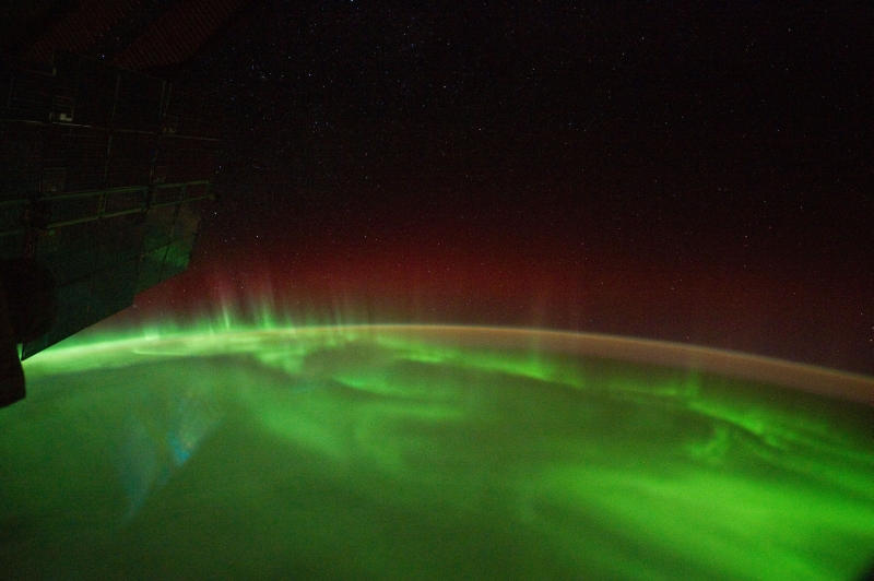
1. Stars, Earth's Airglow, Green and Red Aurora Australis, and Clouds Over the Indian Ocean, March 10, 2012 at 13:20:33 GMT
As Seen From the International Space Station (Expedition 30)
Latitude (LAT): -45.3 · Longitude (LON): 120.6 · Altitude (ALT): 215 Nautical Miles · Sun Azimuth (AZI): 229° · Sun Elevation Angle (ELEV): -29° |
| |

Huge Large Medium Other
2. A River of Light: Stars, Red and Green Aurora Australis Over the Indian Ocean, September 18, 2011 at 13:28:30 GMT
As Seen From the International Space Station (Expedition 29)
Latitude (LAT): -50.7 · Longitude (LON): 137.7 · Altitude (ALT): 209 Nautical Miles · Sun Azimuth (AZI): 204° · Sun Elevation Angle (ELEV): -39° |
| |

Huge Large Medium Other
3. Green and Red Aurora Australis Over the Indian Ocean, September 18, 2011 at 13:29:00 GMT
As Seen From the International Space Station (Expedition 29)
Latitude (LAT): -50.2 · Longitude (LON): 140.5 · Altitude (ALT): 209 Nautical Miles · Sun Azimuth (AZI): 201° · Sun Elevation Angle (ELEV): -40° |
Photo Credits:
1. First Row (Full size Original, Huge, Large, Medium, or Other): NASA; ISS030-E-130215, International Space Station (Expedition 30); Image Science and Analysis Laboratory, NASA-Johnson Space Center. "The Gateway to Astronaut Photography of Earth." <http://eol.jsc.nasa.gov/scripts/sseop/photo.pl?mission=ISS030&roll=E&frame=130215>; National Aeronautics and Space Administration (NASA, http://www.nasa.gov), Government of the United States of America (USA).
2. Second Row (Full size Original, Huge, Large, Medium, or Other): NASA; ISS029-E-7500, International Space Station (Expedition 29); Image Science and Analysis Laboratory, NASA-Johnson Space Center. "The Gateway to Astronaut Photography of Earth." <http://eol.jsc.nasa.gov/scripts/sseop/photo.pl?mission=ISS029&roll=E&frame=7500>; National Aeronautics and Space Administration (NASA, http://www.nasa.gov), Government of the United States of America (USA).
3. Third Row (Full size Original, Huge, Large, Medium, or Other): NASA; ISS029-E-7510, International Space Station (Expedition 29); Image Science and Analysis Laboratory, NASA-Johnson Space Center. "The Gateway to Astronaut Photography of Earth." <http://eol.jsc.nasa.gov/scripts/sseop/photo.pl?mission=ISS029&roll=E&frame=7510>; National Aeronautics and Space Administration (NASA, http://www.nasa.gov), Government of the United States of America (USA).
The Manguaguan na Palabran Si Yuus Archive
The Great Earthquake and Catastrophic Tsunami of 2004
The Spectacular Clouds of the Transonic Flight Regime
The Chamorro Bible In Print


